AIFlame
Applying artificial intelligence to NOAA’s data archives to improve fire prediction at weekly, monthly, and longer time scales
Overview
NOAA is developing an advanced capability to predict wildfire risk and burn behavior from weather forecasts and land cover information. By investigating both long- and short-term conditions before fire outbreak periods, the project will leverage artificial intelligence and diverse datasets to understand complex relationships (including the effects of climate change) and ultimately deliver a predictive forecast-driven algorithm that assesses fire risk weeks, months, or possibly even years before extreme fire outbreaks. This work leverages fire record curation, digitization, management and access capabilities developed in a companion effort.
The wildfire risk assessment algorithm will aid stakeholders in planning for wildfire outbreaks at climate timescales, including the logistical concerns such as equipment and perhaps even planning for labor needs. Current wildfire risk assessments tend to be on shorter ‘tactical’ timescales and/or do not leverage AI tools. The alert system will enhance NOAA’s monitoring capabilities in the direction of detecting climate-scale signals in observational records, whereas the majority of NOAA’s current climate monitoring posture involves set analyses run at months’ end. New gridded humidity and vegetation datasets will support wildfire risk assessment and numerous other applications.
|
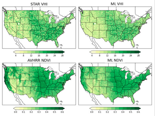
▶︎ The results of Machine Learning (ML) tests and observed vegetation products are mapped to show the spatial distributions. Input variables include meteorological variables and climate indices. The target variables are the Normalized Difference Vegetation Index (NDVI) and the Vegetation health index (VHI). Observed vegetation products are obtained from NOAA’s Center for Satellite Applications and Research (STAR) and the Advanced Very High Resolution Radiometer (AVHRR) suite of products. |
|
Application site(s)
USA
Data
Satellite
An algorithm for characterizing wildfire risk potential is currently under development. Input and output to be finalized by user engagement and development. As with many Artificial Intelligence projects, a large number of input datasets are being included as potential input:
- satellite-derived fire occurrence information from the complete period of record (~1978- to present)
- nClimGrid daily
- new 2.5 km fields of humidity of vegetation cover that are in development,
- Normalized Difference Vegetation Index NDVI,
- drought indices.
Skill is being assessed and the datasets included in the final risk assessment algorithm will be determined as part of this project.
Results - Final product(s)
The results of this project are intermediate scientific products, mostly algorithm development. It is anticipated that further projects will be utilized to operationalize and provide access to any products ultimately developed by this work. Two main datasets will be produced:
- New 2.5 km fields of Humidity, NDVI, and Vegetation Health Index
- Characterizations of wildfire risk at weekly and monthly lead times
Related project(s)
ArcticFire, a SCO USA project to adapt to the evolution of fires in the polar regions (page to be published shortly)
FireAlert, a SCO China project dedicated to forest fire monitoring and early warning in Sichuan


