

FireAlert

Forest Fire Monitoring and Early Warning in Sichuan
Overview
As climate change increases the frequency of forest fires, effective monitoring and early warning systems are crucial. Current methods are often inadequate, relying on costly, continuous monitoring and manual analysis.
This project wants to apply deep learning, along with remote sensing data to create a forest fire risk early warning system to precisely predict hidden risks of forest fires. It is aimed at facilitating intelligent analysis of information regarding forest fire and its surrounding affected entities, and then to predict the forest fires happening, spreading, as well as the risk levels of the studied forests.
|
👉 The system will provide early warnings, help forest guards with preventive measures, and support emergency decision-making during fires, enhancing overall risk assessment and management capabilities. |
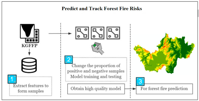
Architecture of forest fire risk probability assessment. © The Aerospace Information Research Institute, Chinese Academy of Sciences |
Application site(s)
China:
- Xichang, Sichuan
- Muli, Sichuan
Data
Satellite
- China Brazil Earth Resources Satellite No.04 (CBERS-4)
Other
- Meteorological data (from the European Centre for Medium-Range Weather Forecasts – ECMWF)
- Terrain data (by the United States Geological Survey – USGS)
Results - Final product(s)
Thanks to a toolset primarily focused on the months of March and April, when forest fires tend to be more frequent, FireAlert can forecast fire risk for the upcoming March and April based on data from the same months over the past several years.
The results will be presented as forest fire risk profiles in reports for this project, and hopefully as a website interface in the near future.
The end-users include not only project partners but also government agencies, forest management organizations, and researchers who are focused on forest fire prevention and mitigation.
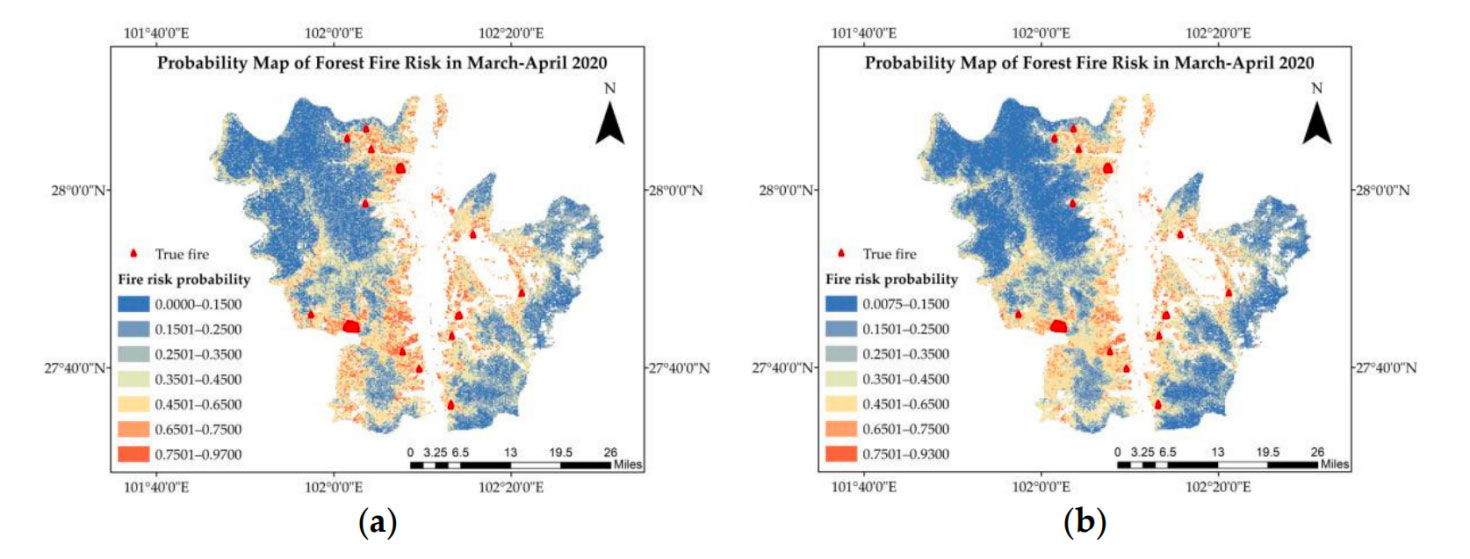
Probability map of forest fire risk in March-April 2020 based on firedata in Xichang from March and April 2015 to March and April 2019. (a) Prediction based on Random Forest (b) Prediction based on Deep Random Forest. © The Aerospace Information Research Institute, Chinese Academy of Sciences
References
Ge, X. ; Yang, Y. ; Chen, J. ; Li, W. ; Huang, Z. ; Zhang, W. ; Peng, L. Disaster Prediction Knowledge Graph Based on Multi-Source Spatio-Temporal Information. Remote Sens. 2022, 14, 1214. https://doi.org/10.3390/rs14051214