

VIET-ARRO

An observatory for resilient recovery in agriculture
Project completed
Viet-ARRO was closely linked with VNDMA, which stands for the Vietnam Disaster Management Authority from the Ministry of Agriculture and Rural Development (MARD) playing a central role in coordinating and implementing disaster response measures throughout the country. In this frame, we studied climate change effects, i.e., floods, droughts and saline intrusion onto rice agriculture. The resulting flood and saline intrusion maps and associated affected rice are browsable and downloadable in the VietSCO platform.
OVERVIEW
|
Vietnam is one of the countries most exposed to extreme climate-change related events (Adger, 1999; Yusuf and Francisco, 2009). Although the country has always suffered from heavy rainfall and flooding caused by rivers in spate, the frequency of extreme climate events, such as typhoons, has been seen to increase in recent years, leading to loss of human life and substantial damage. These catastrophic events activate emergency response mechanisms, with Earth observation data being sent to civil protection agencies for use in producing emergency response maps. However, this stops after a few days. |
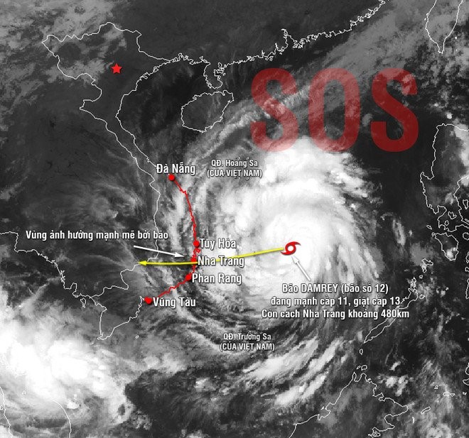
Satellite image of Typhoon Damrey, November 2017. © Facebook Thời tiết Hà Nội |
Following a crisis, it is essential to get the economy up and running again quickly and efficiently. In 2017, a report from Vietnam’s Central Committee for the Prevention and Control of National Disasters raised a number of questions on control, rebuilding and prevention following natural catastrophes. In particular, it underlined the lack of emphasis placed by the rebuilding process on cutting greenhouse gas emissions or increasing resilience to reduce the impact of similar catastrophes.
The aim of the Viet-ARRO project is to set up an Agriculture Resilient Recovery Observatory in Vietnam, relying primarily on satellite observation data. In the event of a major disaster with a severe impact on agricultural output, the observatory could be activated by local or national government or by international development aid organisations.
By using Earth observation data acquired throughout the return to normal and covering the whole of the affected area, it will be possible to monitor the effective progress of regional rebuilding. In this way, the observatory will help to make the rebuilding process as resilient as possible to similar catastrophes in the future. This type of observatory would support regional planning policies, aimed at adapting the rebuilding process to the projected impact of climate change.
The project will involve supplying local and national managers with regularly updated geospatial data based on Earth observation in order to:
- Improve impact assessment and the monitoring of damage suffered by socio-agronomic systems following a typhoon, super typhoon or other extreme hydrometeorological event;
- Provide decision-makers with a range of geospatial data to support post-typhoon recovery;
- As part of the recovery effort, support the transition to low-emission systems that would be more resistant to future climate disasters, with details of the key questions and parameters to be monitored in order to plan a resilient recovery.
Application site(s)
- Regions of Central Vietnam (Hà Tĩnh)
- Regions affected by typhoons during the project
DATA
Satellite
- Copernicus Sentinel-1A and1B. Time series every six days, with a resolution of 10m
Other
- Climate data from weather stations in Vietnam and regional simulations (SEACLID/CORDEX-SEA project)
- Products supplied by the International Charter on “Space and Major Disasters” and by the Copernicus Emergency Management Service in the event of activation in Vietnam
RESULTS - FINAL PRODUCTS
The resulting flood and saline intrusion maps and associated affected rice are browsable and downloadable in the VietSCO platform.
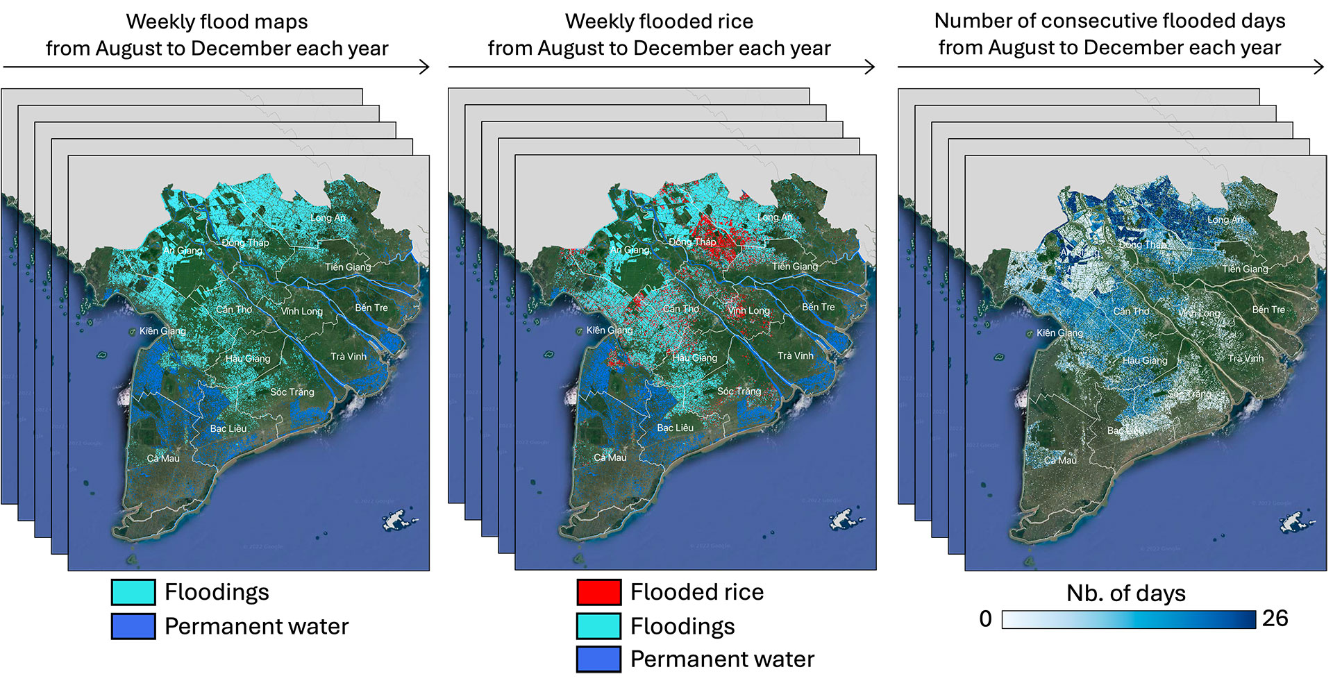
💧 The flood extent maps were generated in the Mekong and Red River Deltas from 2016 to 2020, during the flood season (e.g., from August to December in the Mekong Delta) from Sentinel-1 images.
👉 The multi-temporal analysis of flooded maps allowed to produce the flood duration maps, expressed in number of flooding days, from the beginning of floodings until recession. Permanent water bodies maps have also been derived to differentiate permanently flooded areas from flash floods. Then, flood maps were generated by excluding permanent water bodies. The flood maps were particularly scrutinized in Northern Vietnam in July 2018, just before and after the Son Tinh Typhoon (19-21 July 2018). Flood maps were generated every 6 days after the typhoon, until complete water recession. Finally, the affected rice areas have been assessed by the combined analysis of flood and rice maps. A pixel has been considered as affected if in both the rice and flood maps
|
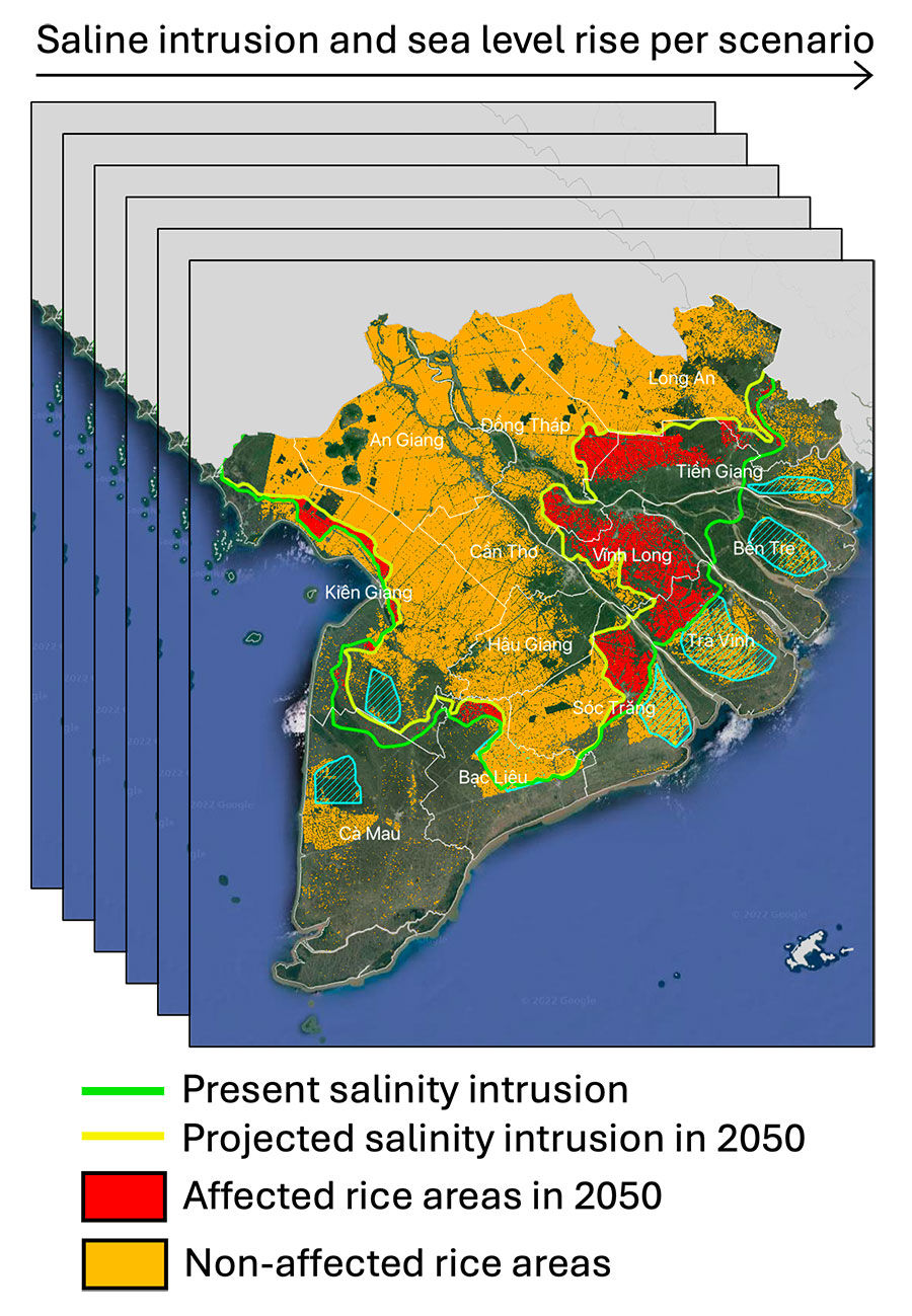
🌾 Potential rice harvest loss due to salinity intrusion was quantified to assess to what extent and where the land will become unsuitable to rice cultivation in future scenario of salinity intrusion. The Vimesco-Rice dry season rice maps were selected to look at where rice can grow. 👉 The large quantity of affected rice under RCP8.5 scenario by 2050 highlighted the need of adaptation by farmers and regulation by authorities. The Mekong delta people already have adaptation measures for salinity intrusion (sluices, dykes, reducing the dry season rice). By 2050 though, the impacts on rice area appear to be more severe with increased anthropogenic pressure. |
|
✚ Read all about the development of the VietSCO platform in the final report available in the Resources section below.
RELATED SCO PROJECTS
-
Vimesco Rice (Mitigating the climatic effects on rice cultivation)
-
Mérimée (Mekong Rice Methane Emissions)
PROJECT NEWS
- 29/03/2023: Presentation of the Viet-ARRO project and its progress at the 8th Quarterly Meeting of the SCO France dedicated to SCOlutions to hydrometeorological risks, including an introduction on the use of satellite data in the different phases of risk management
- 20/07/2022 : VietSCO at the heart of France-Vietnam cooperation with a feedback workshop in Hanoï