

Vimesco-Rice

Mitigating the climatic effects on rice cultivation
Project completed
Addressed to the Vietnamese Ministry of Agriculture and Rural Development (MARD) and the Ministry of Natural Resources and Environment (MONRE), the VietSCO platform is now online and operational. This platform offers seasonal rice cropping maps and annual maps of rice crop density. The Vimesco-Rice project has thus demonstrated the ability to produce reliable rice maps using free Copernicus satellite data.
OVERVIEW
The Mekong Delta has been significantly affected by climate change in recent years. Droughts of increasing frequency, duration and intensity, along with flooding and saltwater intrusion, pose a growing threat to domestic rice production in Vietnam. In 2016, for example, spring rice production dropped by 17% in the Mekong Delta, following a drought that was intensified by the El Niño phenomenon.
To address these inescapable climate changes, the Vietnamese Ministry of Agriculture and Rural Development (MARD) and Ministry of Natural Resources and the Environment (MONRE) need to make decisions on the short- and long-term management of rice production. To this end, decisions are currently based on data collected in-situ at local level (villages, provinces, etc.) and collated in a national statistics database (General Statistics Office).
To support this decision-making process, the project has implemented a tool for monitoring rice-growing areasusing radar-based remote sensing data to map information that complements and/or replaces in-situ data and statistics (area planted, maturity, crop calendar, productivity indicators, number of harvests per year).
Application site(s)
Mekong Delta
DATA
Satellite
- Copernicus Sentinel-1A and 1B. Time series every six days, with a resolution of 10m
Other
- Climate data from weather stations in Vietnam and regional simulations (SEACLID/CORDEX-SEA project)
- Socio-economic data: Vietnam Household Living Standard Surveys (VHLSS) – General Statistics Office of Vietnam
- In-situ data on rice growing
RESULTS - FINAL PRODUCTS
VietSCO is a free, open-access platform for monitoring production status and harvest forecasts, as well as simulating various climate change scenarios in order to define mitigation measures (modified rice-growing calendar, fewer harvests per year, changing land use).
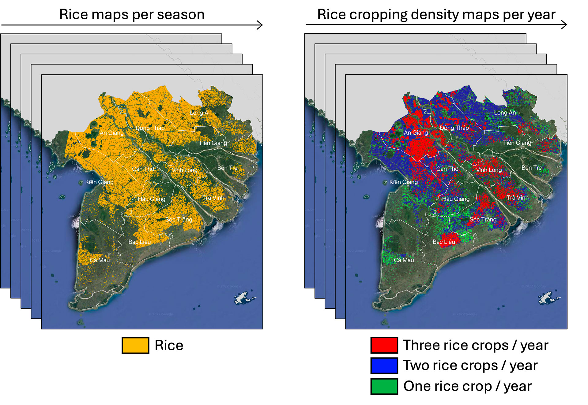
🌾 The rice maps produced from Copernicus Sentinel-1 in the Mekong and Red River Deltas in Vietnam were validated with more than 90% of accuracy.
👉Twelve rice seasons within a four-year period (2016-2020) were aggregated to produce rice cropping density maps. These rice maps were crosses with maps of flooding, drought, and saline intrusion under various climate change scenarios to assess potential future losses in rice fields. These efforts were developed as part of the SCO Viet-ARRO project, conducted in parallel with Vimesco-Rice.
Outlook
The Vimesco-Rice project contributed to the labeling of the SCO Mérimée project in 2023. Methane emissions from rice fields will be estimated more accurately than the methods currently used, thanks to the mapping of continuously flooded rice fields and rice fields flooded in alternate wet and dry mode.
RELATED SCO PROJECT
-
Viet-ARRO (Vietnam Agriculture Resilient Recovery Observatory)
-
Mérimée (Mekong Rice Methane Emissions)
PROJECT NEWS
- 20/07/2022 : VietSCO at the heart of France-Vietnam cooperation with a feedback workshop in Hanoï
- 09/06/2021: Video (YouTube, in French) Vimesco-Rice, radar remote sensing for rice production: extract from the First Quarterly of the SCO France, where the project is presented under the angle "use of satellite data" followed by a progress report.
- 06/05/2021: the second Users and Science Team meeting and a bilateral working meeting with the VNDMA (Vietnam National Disasters management Agency) allowed to complete the project documents describing the users needs. These documents are currently being translated into Vietnamese.
- April 2021: First results of scientific studies obtained by crossing rice field maps, drought indices and salt water intrusion over the period 2015-2020