

SCOFrance
62Connected participants
Next quarterlySeptember 2024
Theme: Air quality
Water and coastal quality
The facts are clear: whether marine or freshwater, water quality is deteriorating all over the world, with serious consequences for people and the environment. When it comes to vital issues such as food security and health, satellites can provide powerful tools to inform and support sustainable management of water and coastal ecosystems.
On Thursday 20 June 2024, the 13th Quarterly Meeting of the SCO France welcomed three projects that use spatial data to monitor the quality status of continental and coastal surface waters.
If you have any questions about this quarterly, write to us here.
By Marie Jagaille and Marc Lennon (Hytech-imaging)
|
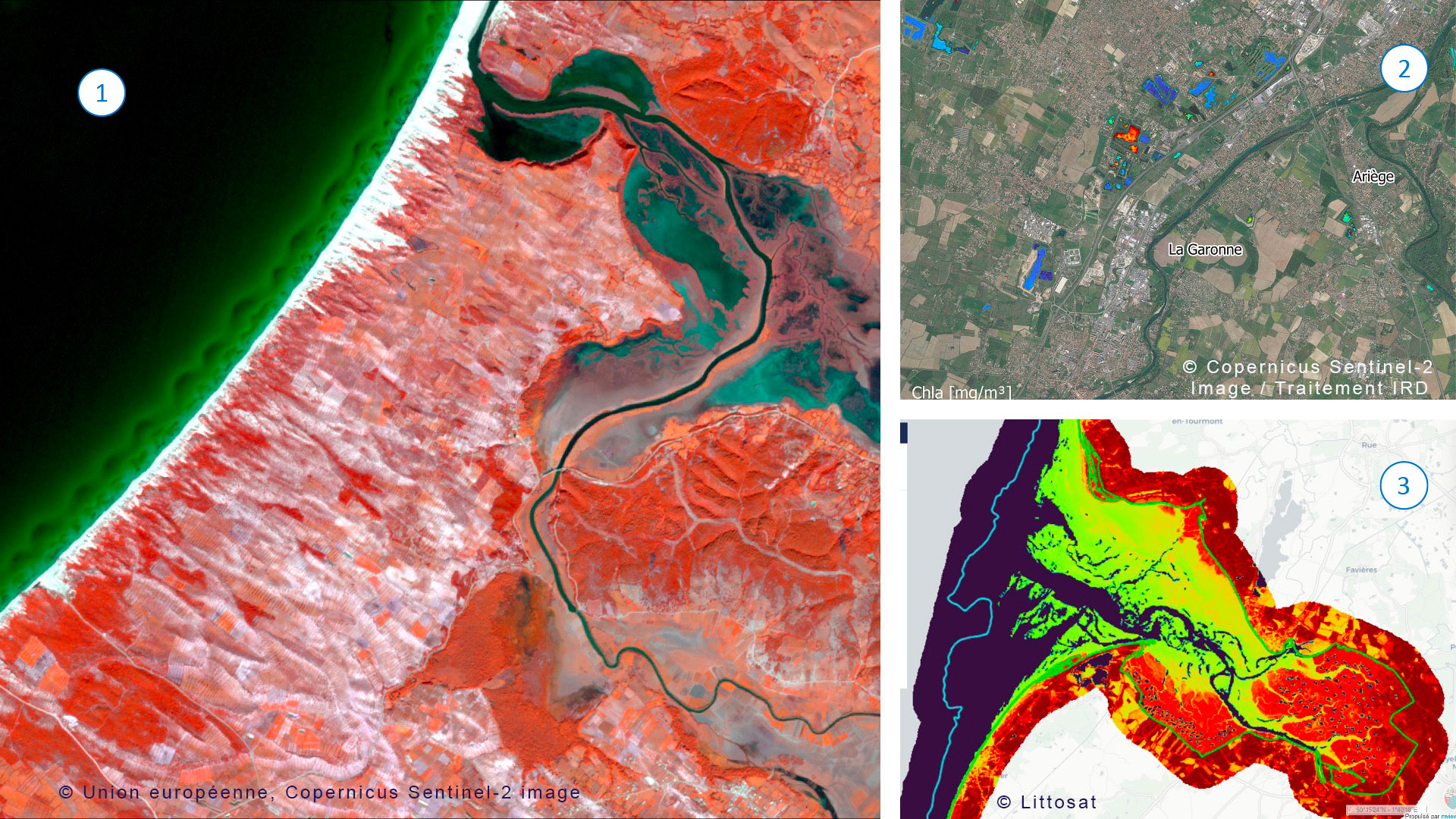
In France, coastal areas are densely populated and host a range of human activities that have an impact on ecosystems: only 5% of species and 6% of marine and coastal habitats are in a favorable state of conservation... Against this backdrop, LITTOSAT brings together and processes previously unpublished satellite data to build a tool for monitoring the state of health of foreshore inhabitants. It is particularly aimed at managers of coastal areas and marine protected areas. Watch the video opposite for demonstrations of the LITTOSAT platform. |
|
To remember
- Satellite data used:
- Sentinel-2, free of charge with an exceptional revisit time (every 5 days), via a Copernicus API;
- SPOT and Pléiades via Dinamis (to which the project has subscribed thanks to the SCO) and the IGN feed.
- On a mosaic combining these images to provide a uniform, uncluttered regional view, the system shows habitats at high tide and low tide, the latter being generally less well known because they are often underwater.
- The user can choose between a display in natural color or in infrared, which makes it easier to highlight underwater and non-underwater areas.
- It promises to be an extremely powerful tool, with strong interconnections with other SCO projects, including SCOast-DT, which was accredited with the SCO label in March 2024 to build digital twins along the coast.
💡 News: 2 demonstrators already online, in Brittany and Normandy.
By Jean-Michel Martinez (IRD)
|
There are thousands of small dams, and they play a crucial role in ecosystems and human activities. In an innovative approach, XtremQuality is developing automated monitoring of these reservoirs based on quality variables that can be observed from space and applied to objects that are not monitored by the public authorities, including artificial reservoirs, which are expanding rapidly in an agricultural context that is under pressure. XtremQuality provides hitherto unknown but essential information. |
|
To remember
- Based on Sentinel-2 data, XtremQuality generates water quality maps with spatial indicators to classify them according to their characteristics.
- The team is also working on vulnerability and resilience indicators.
- XtremQuality results will be accessible via the Hydroweb.next platform.
- The models can be transposed to any location, whatever the context (wet, arid, semi-arid, etc.) and the issues involved.
💡 News: First trial in south-west France
By Nina Bègue (La Tour du Valat)
|
While the Mediterranean is at the heart of the concerns linked to climate change, the wetlands it borders are in serious trouble, as they are being converted into agricultural, urban and industrial zones... No fewer than 27 countries are involved, each with their own environmental protection policies. AIonWetlands collects all the relevant information on the state of these ecosystems, the trends observed and the main threats. Watch the video to see a demonstration of the platform currently under development. |
|
To remember
- The system first generates wetland habitat maps for the 320 sites monitored (and therefore instrumented) by the Mediterranean Wetlands Observatory.
- Using AI, which learns to classify wetlands on the basis of satellite images from these monitored sites, the system will generate predictive habitat maps for 100 additional sites that are not monitored.
- Currently under development (and well advanced!), the final geoportal will display maps of wetlands and their indicators at the scale of a site or a country.
- A user test will be launched very shortly to ensure that the portal meets the expectations and needs of managers in the various countries.
- Objective: presentation of the results at Ramsar COP-15 (International Convention on Wetlands) in July 2025.
💡News: AIonWetlands on the home straight
💧To find out more: SCOlutions to Sustainable Development Goal 6 on "clean water" and its sustainable management.