

SCOFrance
3Successive floods over 2 days predicted
Useful linksPresentation of the project
Key wordsBengal delta, cyclone, cyclonic flooding, forecasts, warning
Use case: BandSOS put to the test by Cyclone Remal
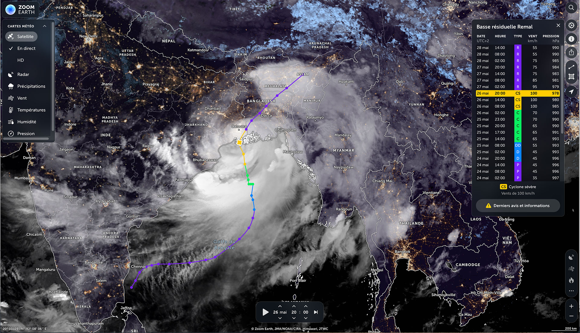
On Thursday 23 May, Bangladesh and India were placed on red alert by their respective national meteorological services, the IMD and the BMD (Indian/Bangladesh Meteorological Department). The culprit: Remal, a tropical storm that will become a powerful cyclone in just three days. In the Bengal delta, the public authorities are de facto consulting the SCO BandSOS demonstrator to monitor potential flood conditions. Developed by LEGOS with the local authorities and made available to them in its pre-operational version, the BandSOS demonstrator confirms the alert, with forecast curves rising steeply.
|
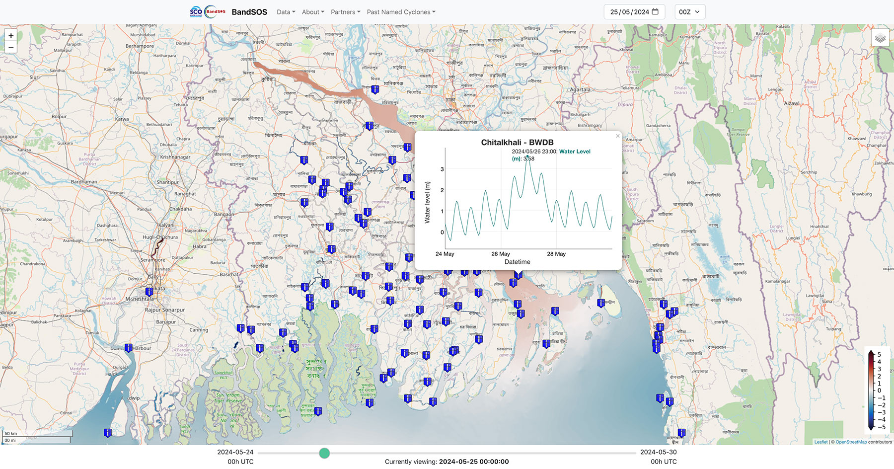
► BandSOS forecast for 25 May 2024. The temporal evolution of the water level shows 3 successive peaks from noon on 26 May to 10am on 27 May, here at the Chitalkhali station in the heart of the delta. © BandSOS |
|
On Sunday 26 May, Remal arrived and raged for 36 hours, making it one of the longest cyclones in the world. According to the authorities, more than 800,000 Bangladeshis fled the country's coast. Among the extensive damage reported in the local press [Dhaka Tribune on 29 May 2024 and The Daily Star on 13 June 2024], a total of 4.6 million people were affected, 40,000 homes were destroyed and 133,000 damaged. The fishing and agricultural sectors suffered particularly heavy losses.
Accurate forecasts despite unusual cyclonic behaviour
According to Jamal Khan, research engineer at LEGOS and designer of BandSOS, "we are awaiting the report from our Bangladeshi partners, including their instrumental data, but, in fact, the flooding pattern predicted by BandSOS corresponds well to what was observed, with 3 successive episodes of submersion over 2 days and a maximum water level of 2 to 3 meters above high tide. Unexpectedly for the BWDB engineers, the third episode of flooding predicted by BandSOS well after the arrival of the cyclone, on the afternoon of 27 May local time, proved to be correct".
This is surprising, because "as a general rule, we expect a cyclone to weaken and no longer cause flooding once it has made landfall. However, not only did Remal retain its strength as it crossed the Bangladeshi landmass, but, as a further fortuitous event, it also moved along a 'favorable' track, continuing to push water through the rivers towards upstream over three consecutive high tides, a situation that is conducive to the creation of flooding water levels. Thus, even in the next day of cyclone landfall, high water level was generated [3rd peak in the figure below]. Thanks to the coupling of our tide-surge-wave model, the only one operational in this region, we could capture not only surges, but also how storm surge and high tide combines to generate extreme water level," explains Jamal Khan.
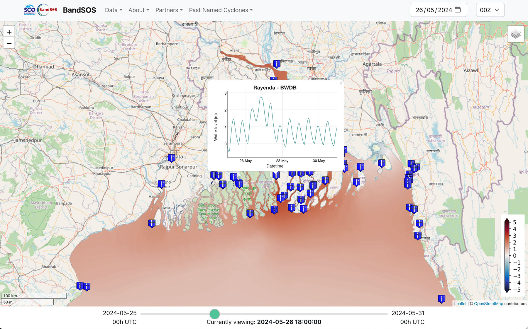
Against all the odds, BandSOS accurately predicted water levels of over 2.50 metres more than 50 km inland by the afternoon of 27 May. © BandSOS
Testimony from the Flood Forecasting and Warning Center FFWC
Despite the complicated situation requiring all his attention on the floods in the north-east of the country, Sarder Udoy Raihan, executive engineer of FFWC, the main partner in the project, agreed to answer our questions, for which we thank him.
How was the BandSOS system used to deal with Cyclone Remal?
Sarder Udoy Raihan: BandSOS was used extensively during the cyclone, however the use and destination was kept in the internal BWDB (Bangladesh Water Development Board) channel only, which is under the FFWC. The system showed us the expected surge height both in the coastal region and in the inland rivers as well, which helped the field officials to be prepared for the inundation and probable over topping or bank-erosion and take emergency measures in vulnerable areas.
Was the BandSoS forecast consistent with the floods observed?
Sarder Udoy Raihan: BandSOS forecast was close to the real scenario, comparing the water level rise in different points according to our initial observation. We may use the observed data from automatic sensors to validate it further.
What initial infrastructure damage has been observed? What do you think could be done in the future to improve BandSOS flood predictions?
Sarder Udoy Raihan: Approximately around 300 km of protective works were partially damaged or breached during cyclone Remal, based on assessment up to current date. For e more effective flood forecast, we can suggest correcting the BandSOS output with our MSL* datum and the observed water level so that we may get a more accurate level.
* MSL stands for Mean Sea Level and refers to the average sea surface level, considered as a reference level. In very simplified terms, it is the median line between a mean low tide and a mean high tide at a particular coastal location, excluding the influence of waves. Measured using space altimetry, it is the MSL that is increasing in response to global warming (as the Aviso website explains so well).
🖱️ Test BandSOS. You can access the Remal forecasts directly from the "Past named cyclones" menu.
💡BandSOS was presented on 18 July 2024 at the UN/Austria Symposium by Mr Sazzad Hossain, Director of the Hydroinformatics & Flood Forecasting Circle ( Flood Forecasting and Warning Center ) in Bangladesh.