

Strata

Custom Climate Security Analytics
Project completedStrata has delivered the https://unepstrata.org/ website and its online mapping platform. This enables the visualisation of hotspots where environmental and climatic-related stresses converge with insecurity and socio-economic vulnerability.
Overview
As we start to see the impacts of climate change, there are growing concerns over how cumulative changes in the environment impact livelihoods. The links between environmental change, climate stresses, conflict and vulnerability of populations are complex, and access to data on such topics is not straightforward.
This was the rationale behind the development of Strata, delivered through a collaboration between Earth Blox, the United Nations Environment Programme (UNEP) and the University of Edinburgh. Strata was co-designed as a tool to assist over 130 UN country teams bring together data from diverse sources and give them greater clarity on where stresses were at their highest. By identifying the stresses from different sources, and converging them into one platform, users are able to see the “hotspots” – those areas most at risk.
Stata demonstrates:
- The convergence of environmental stressors
- How/why the intensity of these “hotspots” changes
- Where these hotspots interact with other social and economic variables to increase the risk of fragility, social conflict, migration or maladaptation
Strata allows end users to generate products that can input to conflict and fragility analysis systems & multi-hazard risk assessments and early warning platforms.
Application site(s)
Implemented in Somalia (Africa) in particular, Strata covers the whole world.
Data
Satellite
- Google Earth Engine
- Sentinel-2
- MODIS
- SRTM
- Landsat
- ACLED
- FEWS NET
- WorldPop Global Project Population Data
- VIIRS
- The Malaria Atlas Project
Results - Final product(s)
The project was successfully concluded and handed over to the end users in Sahel and West Africa. There is also a publication here: https://unepstrata.org/
Details of the project can be found in the documents available to download in the Resources section below.
|
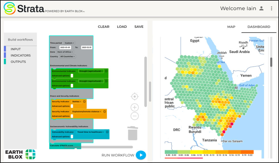
► Building your customizable workflow on the Strata platform. |
|
|
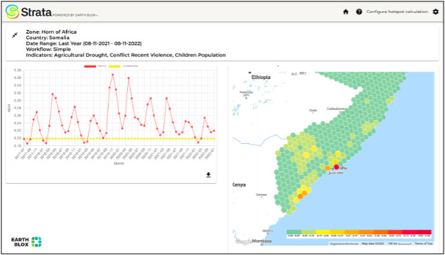
▶︎ Strata outputs analysis in various forms. |
|
|
► Strata case study: Earth Blox & UNEP Strata Keynote at Geo4Good 2021 |
|
References
| Strata on GEO Knowledge Hub, a long lasting digital repository created by the Group on Earth Observations: https://doi.org/10.60566/sgvj9-s9j30 |
- H. R. Young, Y. Cha, H. den Boer, M. Schellens, K. Nash, G.R. Watmough, K. Donovan, G. Patenaude, S. Fleming, B. Butchart, I. H. Woodhouse. Strata: Mapping climate, environmental and security vulnerability hotspots : https://doi.org/10.1016/j.polgeo.2022.102791
Related project(s)
SCO SAFAFRICA, Informing Food Security Assessments in Developing Countries