SAFAFRICA
Informing Food Security Assessments in Developing Countries
Overview
NOAA uses satellite data from the past 40 years, combined with in situ data and models, to estimate precipitation and surface temperatures, helping to assess drought and famine severity, particularly in data-sparse regions like Africa. For this, it uses GridSat Climate Data Record (CDR), which simplifies the access to data by providing mapped data that has been intercalibrated.
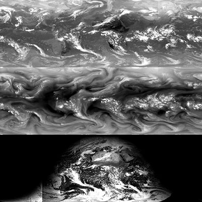
This dataset provides scientific researchers a high-quality Climate Data Record (CDR) of global infrared (IR) measurements from geostationary satellites. The GridSat-B1 data facilitates geostationary data usage for wide range of applications. The complete dataset provides data from 3 channels: the CDR-quality infrared window (IRWIN) channel (near 11 μm), the Visible channel(near 0.6 μm) and the Infrared water vapor (IRWVP) channel (near 6.7 μm).
Because regions with food insecurity also suffer from poor in situ coverage, the GridSat CDR is used in two products to help provide observations in data sparse regions:
- CHIRPS - the Climate Hazards group Infrared Precipitation with Stations - is a merged precipitation record from models/satellite/in situ.
- CHIRTSmax - CHIRTSmax is the Climate Hazards group Infrared Maximum Temperature with Stations - is a record of land surface maximum surface temperature dataset from satellite/model/in situ data.
Thanks to these data, the FEWS NET (Famine Early Warning Systems Network), partner of this project as an end user, provides information to food providers and international organizations using information on the cutting edge of drought early warning service, informing food security outlooks that save lives and livelihoods in high-risk countries.
Application site(s)
Global data – mainly in Africa
Data
Satellite
GridSat B1 CDR data, produced from several meteorological geostationary satellites from 1980 to present. This includes more than 30 different satellites from 5 data providers.
Results - Final product(s)
The tool developed by NOAA us the combination of the satellite data (GridSat) with other information to allow informed decisions to prevent droughts and the associated risks of food insecurity. Therefore, the project has developed the workflow to ensure the data are prepared and ready for stakeholders. The project tool is in operational use but continues to be evaluated and improved through iterative feedback with the Famine Early Warning Systems Network (FEWS NET) community and others in the production pathway.
👉 The intermediate users are the Climate Hazards group at University of California Santa Barbara (UCSB), who use GridSat in concert with model and in situ data in order to produce more complete (viz. improved coverage) global temperature and precipitation data.
👉 The end users include the FEWS NET team and the food security industry, who use the products from several sources, including the Climate Hazards group, to make decisions. Government agencies are also potential end users.
Related project(s)
SCO Strata, Custom Climate Security Analytics


