

SCOFrance
PartnersGlobEO, CESBIO, VNSC, CNES, Rynan Technologies, Bac Lieu and An Giang Universities
Useful linksProject page
VietSCO platform
Key wordsWorkshop, rice fields, methane, remote sensing, machine learning, users
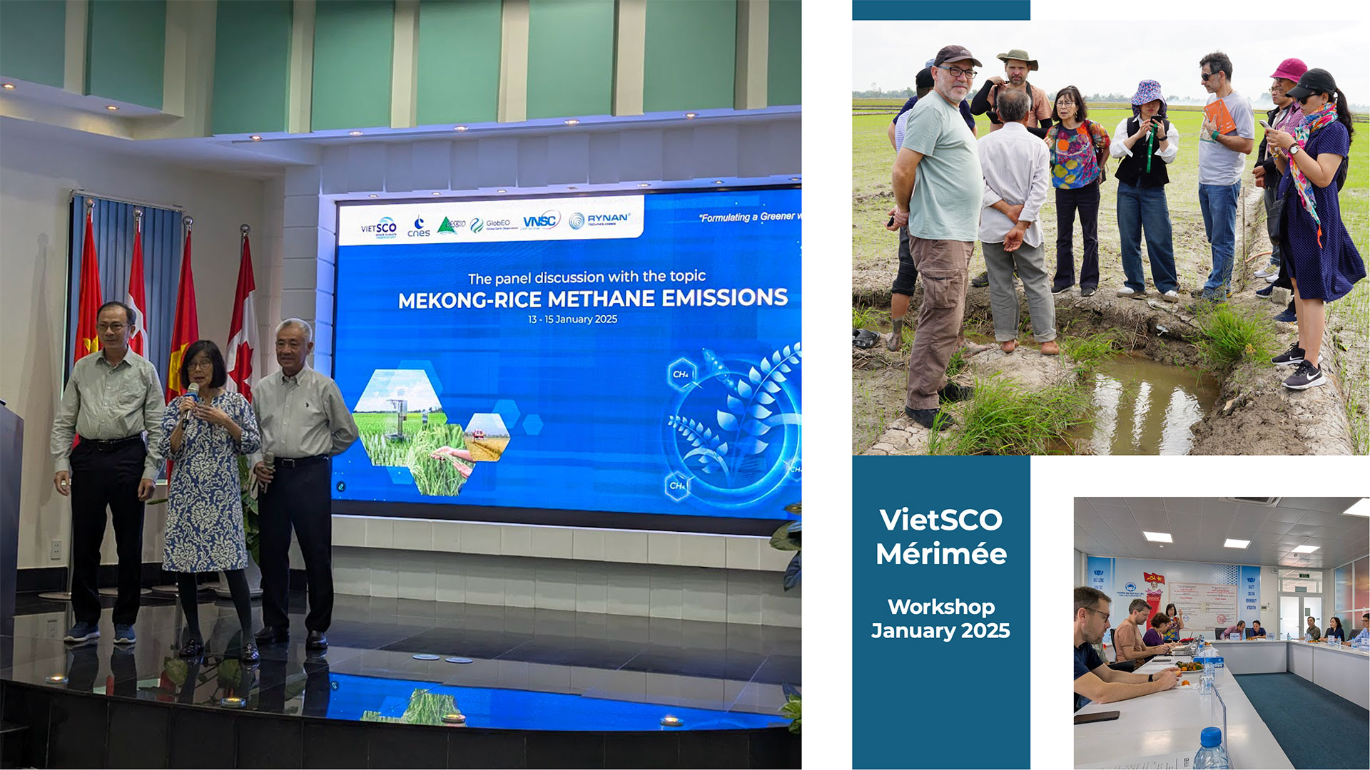
VietSCO Mérimée presents its first results in Vietnam
Among the 155 countries committed to reducing their methane emissions by 2030, Vietnam is focusing its efforts on flooded rice paddies. To demonstrate the effectiveness of intermittent drainage, which is much less emissive without impacting rice yields, and thus encourage a change in cultivation practices, the VietSCO project is developing a tool for monitoring rice fields in the Mekong Delta using spatial data and in situ observations. The aim is to automatically generate dynamic maps of rice paddies at different stages of growth and their flooding status, and then, derived from these, maps of seasonal methane emissions. The products will be displayed on the VietSCO platform, developed as part of previous VietSCO projects (Vimesco Rice et Viet-ARRO).
User workshop
From January 13 to 15, 2025 in Tra Vinh, in the Mekong Delta, the workshop brought together some fifty participants, including the project partners, experts and researchers in space technologies, representatives of local, provincial and national authorities in the fields of agriculture, science, technology and the environment, as well as an international private company and a NGO.
A presentation was made of the project, the VietSCO platform and its new functionalities with Mérimée, and the discussions testified to the good orientation of the work:
- Technological advances in connected soil-measuring devices are providing a better understanding of the relationship between irrigation practices and methane emissions.
- The solution carried by remote sensing data to estimate methane emissions from rice fields seems suitable to extend field observations and in situ measurements obtained by IoT measurement devices, over a vast area such as the Mekong Delta.
- For users, the information, as presented on an accessible platform, has the potential to be used for methane emission control purposes.
Everyone agrees for including user tests to validate the final tool, followed by training to ensure rapid and effective familiarization.
Technical session
The project team set aside one day for technical details, with the aim of encouraging discussion around two themes: the difficulties encountered, and the solutions required to make a rice monitoring tool operational, followed by R&D advances in methane emissions from rice fields.
- Rice field monitoring
After a presentation of the remote sensing method used in the VietSCO project, and of the projects of the Vietnamese space agency VNSC using radar data, it became clear that open-access cartographic products are well suited to national or delta-wide needs. On the other hand, specific needs at commune or district level call for the development of a dedicated service.
- Estimated methane emissions
The estimation of methane emissions from rice fields is based on the IPCC method, which uses specific emission factors depending on whether the fields are permanently flooded or intermittently drained. To estimate methane emissions as a function of flooding and drainage times, the project combines satellite data and in situ measurements.
🛰️ Satellite detection and monitoring of the flooding status of rice fields on a regional scale, even under dense rice plant cover, was demonstrated for the first time, using L-band radar data from the ALOS-PALSAR and SAOCOM satellites. In this respect, the project benefited from ALOS-PALSAR data from the CH4Rice initiative, led in Asia by the Japanese space agency JAXA. Mérimée has demonstrated that the machine learning approach is more effective than conventional parametric models for linking radar observations to in situ measurements.
🌾 In the field, 20 to 30 water level sensors have been installed to accurately monitor flood fluctuations in real time. These sensors complement field visits to 100 plots of land each time the ALOS and SAOCOM satellites pass over.
👉 Analyses of in situ water level measurements have highlighted their diurnal, seasonal and annual variations, which will be incorporated into the algorithm training and validation stages.
👉 Initial analyses of methane emission measurements suggest that the values recommended by the IPCC, which do not take account of diurnal variations in emissions, are underestimated
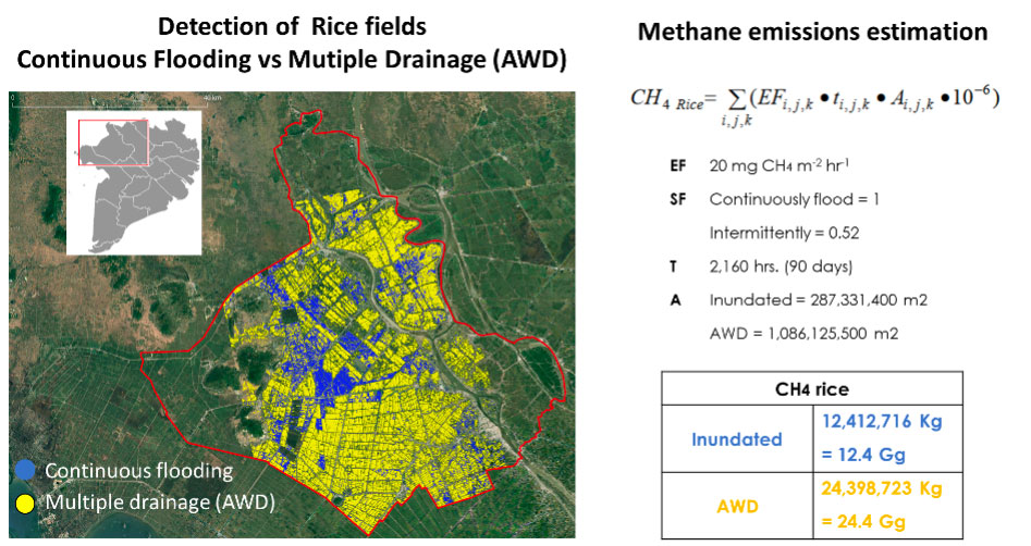
Participants were able to discover the first results of the project. Left: detection of rice fields with continuous flooding (blue) and multiple drainage (yellow) in An Giang province. On the right, estimates of methane emissions in the imaged area. © GlobEO
Visits to the Mekong Delta
After the workshop, the VietSCO team visited two Mekong Delta provinces, Bac Lieu and An Giang, to interview farmers about their practices and exchange views with the university partners in charge of in situ measurements. These visits provided invaluable information for the project, in particular the links between farming practices, soil type and climate change, which will be used to adjust the detection algorithms and feed the machine learning models.
Finally, a protocol visit to the University of Bac Lieu, a partner in the project, identified opportunities for raising awareness among local authorities of the Provincial People's Committee on issues linked to rice growing and the reduction of methane emissions.
Review and outlook
For users, this work has the potential to be used on a national scale to encourage and monitor the reduction of methane emissions. Both the method and the visualization platform have been approved.
On the basis of all these exchanges and information, the project team sets the following milestones:
- Generalize flood detection algorithms for rice fields.
- Evaluate the methane emission factors recommended by the IPCC, using in situ measurements of methane emissions.
- Integrate flood and methane emission maps based on agricultural practice scenarios into the VietSCO platform.
- Prepare user training.