

SUMAG
 mangrove in Gabon.")
A Mangrove Monitoring Platform for Gabon
Overview
Mangroves are recognized as being the most efficient carbon sink. Due to their very high primary productivity and the anoxic soil conditions which limit decomposition processes, mangroves have the capacity to store exceptional quantities of carbon. Despite the many ecosystem services they can provide, such as coastal protection and biodiversity, they are threatened by anthropogenic activities. Thus, their global surface area decreased from 18.8 million hectares to 14.7 million hectares in 25 years.
In Gabon, mangroves, estimated at around 2,500 km² in 1990 (Lebigre, 1990), have an estimated surface area of 1,906 km² in 2020 (Boucka and al., 2022). However, local efforts to stop or slow down the process of loss and degradation of mangroves suffer from the lack of data and knowledge relating to these ecosystems. Given their importance in climate change mitigation (carbon sequestration capacity) and adaptation (coastal protection), their ecosystem must be understood to be protected and monitored. In this context, earth observation tools present considerable advantages, firstly in terms of better repeatability of measurements in this difficult-to-access environment, and secondly in terms of improved discrimination thanks to the multiplicity of satellite sensors.
The SUMAG project aims to develop a platform using earth observation data for mangrove monitoring and management in Gabon to provide a sustainable response to the degradation of this ecosystem.
Application site(s)
Gabon: SUMAG is being implemented in the Estuary Province before extending the system to all Gabonese mangroves.
Data
Satellite
- Sentinel-1 (radar)
- Sentinel-2 (optical)
Results - Final product(s)
The platform will provide seven main functions:
-
Produce reliable and standardized geo-environmental information characterizing mangrove ecosystems;
-
Offer alerts of disturbances affecting mangrove ecosystems and their environment (deforestation and degradation) in near real time;
-
Provide the geolocation of projects/activities carried out near mangroves which have given rise to a prior impact study; Ensure spatial monitoring of mangrove restoration zones;
-
Represent the conservation areas (National Parks, Arboretum, etc.) in which Mangroves are found;
-
Disseminate this information with specific access to institutional actors, ministry managers, communities, etc.;
-
Communicate and inform the general public through the popularization of scientific documents, reports and videos and legal texts and international treaties relating to mangroves;
-
Federate user communities (feedback and developments in the offer)
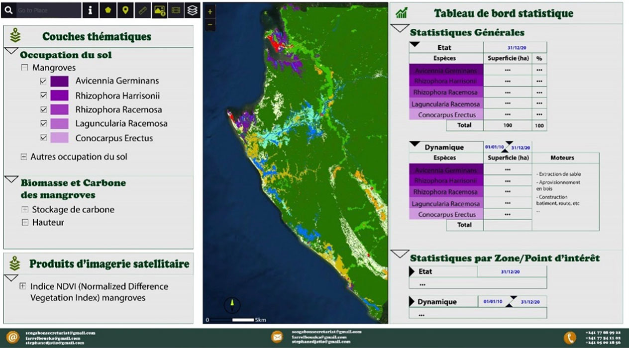
|
► SUMAG Platform home page. © AGEOS |
 |
|
► SUMAG map interface. © AGEOS |
|
References
- ABURTO-OROPEZA, Octavio, EZCURRA, Exequiel, DANEMANN, Gustavo, et al. Les mangroves du golfe de Californie augmentent les rendements de la pêche. Proceedings of the National Academy of Sciences, 2008, vol. 105, no 30, p. 10456-10459.
- BOUCKA, Farrel Nzigou, OBAME, Conan Vassily, MANFOUMBI, Francis, et al. Cartographie de l'occupation du sol du Gabon en 2015-changements entre 2010 et 2015. Revue Française de Photogrammétrie et de Télédétection, 2021, vol. 223, p. 118-128.
- DONATO, Daniel C., KAUFFMAN, J. Boone, MURDIYARSO, Daniel, et al. Mangroves among the most carbon-rich forests in the tropics. Nature geoscience, 2011, vol. 4, no 5, p. 293-297
- FIELD, CHRISTOPHER, OSBORN, JULIE, HOFFMAN, LAURA, et al. La biodiversité des mangroves et la fonction des écosystèmes. Global Ecology & Biogeography Letters, 1998, vol. 7, no 1, p. 3-14.
- GEDAN, Keryn B., KIRWAN, Matthew L., WOLANSKI, Eric, et al. The present and future role of coastal wetland vegetation in protecting shorelines : answering recent challenges to the paradigm. Climatic change, 2011, vol. 106, p. 7-29.
- GHAZALI, Noorzalianee, ZAINUDDIN, Khairulazhar, ZAINAL, Mohd Zainee, et al. The potential of mangrove forest as a bioshield in Malaysia. In : 2016 IEEE 12th international colloquium on signal processing & its applications (CSPA). IEEE, 2016. p. 322-327
- LOVELOCK, Catherine E., CAHOON, Donald R., FRIESS, Daniel A., et al. La vulnérabilité des forêts de mangrove de l'Indo-Pacifique à l'élévation du niveau de la mer. Nature, 2015, vol. 526, no 7574, p. 559-563.
- MANSON, F. J., LONERAGAN, N. R., HARCH, B. D., et al. A broad-scale analysis of links between coastal fisheries production and mangrove extent : a case-study for northeastern Australia. Fisheries Research, 2005, vol. 74, no 1-3, p. 69-85
- NAGELKERKEN, I. S. J. M., BLABER, S. J. M., BOUILLON, Steven, et al. The habitat function of mangroves for terrestrial and marine fauna : a review. Aquatic botany, 2008, vol. 89, no 2, p. 155-185.
- OKANGA-GUAY, Marjolaine, ASSOUMOU, Emmanuel Ondo, AKEN, Igor Akendengue, et al. Suivi des changements spatiaux et environnementaux dans les mangroves de la province de l'Estuaire du Gabon. In : Conférence OSFACO : Des images satellites pour la gestion durable des territoires en Afrique. 2019.
Related project(s)
SCO Mangroves