

SCOast-DT
")
Coastal Zone Digital Twin
Overview
Context
More than two billion people live in the near-coastal zones at the ocean-land interface with almost a billion more living in adjacent low-lying coastal areas. These populations are at risk from increasingly severe storms and longer-term sea level rise in the context of climate change. The issue concerns not only humans but ecosystems in general, with major impacts already observed on the flora and fauna of coastal areas.
As a result, governments in coastal countries are implementing policies to reduce risk and adapt to climate change. Local decision-makers, for their part, must translate these directives into concrete action. This requires an objective, long-term vision. Actions are prioritized according to cost and expected impact. Internationally, there is a wide disparity in the analysis and action capabilities of the various countries concerned. What's more, the subject is handled by a wide variety of public and private players, from the major national institution in charge of risk assessment to the small engineering firm studying a simple urban redevelopment project.
Absent or infrequent measurements, difficulty in extracting relevant information, the need to mix data of different origins and nature... the difficulties encountered in understanding and modeling the coastal environment are numerous, given its complexity and dynamic evolution. Furthermore, not all stakeholders have access to the same data, nor the same skills to process it.
There are solutions for taking regular, quality-controlled and constantly improving measurements on a global scale, with different modalities for obtaining a phenomenal amount of information on the coastal domain: Earth Observation missions. However, to be processed, these data require specific algorithms. To combine them, an additional step is needed to make them superimposable and interoperable. The potential is immense, and demonstrations of use already exist. On a large scale, on the West African coast, as described in Olusegun A. Dada et al, 2023, as well as on smaller scales but with much greater analytical finesse, as in Allen T. et al. 2023 in Hampton Roads, USA.
|
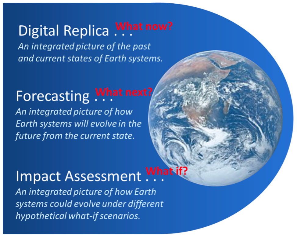
Experts know how to carry out complex analyses of coastal areas, and our aim is to democratize this know-how and break down the barriers that limit its up-scaling. Our project wants to propose a framework for processing, combining and connecting all the information needed to understand the coastal environment and its future projection in the context of climate change, using AI/ML models and technologies. Such a framework has a name: a digital twin.
Figure 1: The main functions of a digital twin. © NASA |
|
The breadth of the topic is immense and covers coastal bathymetry and topography, terrestrial and marine water quality, terrestrial and marine ecosystems, infrastructure and socioeconomic factors. However, it's not a question of reinventing everything, but rather of making the most of all existing developments and data, filling in the gaps and, above all, creating the connections to make the digital twin useful. Exploiting the latter with modeling and projection tools should enable us to answer the questions posed by decision-makers.
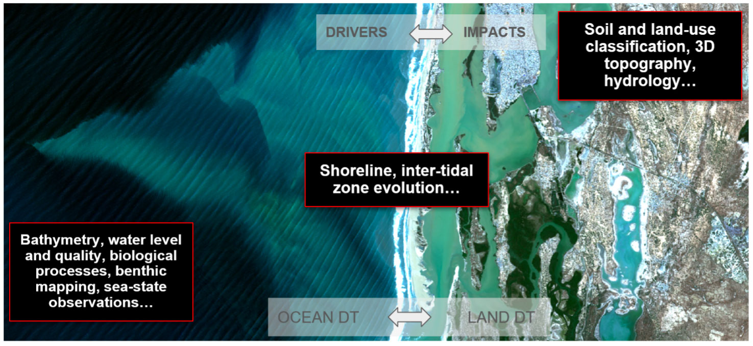
Figure 2: The contribution of spatial data for digital twins of coastal zones. © CNES
Objectives
The main objectives of the project are to create digital twins over different areas, and to address the following use cases:
-
coastal flooding in relation to sea-level rise, tides and extreme weather events. This includes projecting the risk into the future according to climate evolution scenarios and potential means of mitigation.
-
characterization of coastline evolution on a large scale and over several decades using remote sensing data, mapping the dynamics of erosion/accretion processes, comparison and validation with in-situ data. Climate projections will be carried out for smaller areas. On this subject, we aspire to provide a tool equivalent to Dynamic Coast, but with a different and much greater geographical coverage.
-
evolution of coastal ecosystems, indicators of vegetation health and water quality, mapping of shallow waters and the intertidal zone.
SCOast-DT is a project led by CNES, NASA and NOAA, with the overall aim is to harness the power of digital twins powered by satellite data, in-situ data and modelisation to help coastal areas cope with climate change. We also hope that this project will contribute to the structuring of international efforts on digital twins by demonstrating the relevance of this approach on real cases.
Partners and users
The main users of our project are the local authorities of the targeted regions of interest. Our main ambition is to support public action by factualizing the past evolution of the coastal systems studied, while at the same time proposing evolution scenarios in the context of climate change. Here are the connections that have been established so far:
- New-Caledonia: New-Caledonia government, a collaboration agreement with CNES is being setup
- Nokoué, Benin: we will use a LEGOS/IRD local connection
- Hampton Roads Planning District Commission (HRPDC): regional organization representing the area's seventeen local governments to address problems of greater local significance through credible and timely planning (Virginia, US)
In France, the results will be presented and made available to the national institutions in charge of coastal risk evaluation and management: BRGM, IGN, Météo-France, IFREMER and CEREMA. A similar approach can be taken on the US side
The last type of user is the scientific community: coastal science will be boosted by the availability of coastal zone digital twins in different regions of interest. We hope to leverage the community through the open nature of most of the proposed tools and outputs.
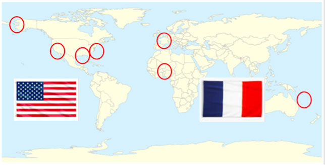
Application site(s)
|
France sites
US sites
|
Figure 3: The SCOast-DT study areas have been chosen to be representative of the diversity of coastal issues. © CNES |
Data
Satellite
- Open remote sensing data: Landsat, Copernicus/Sentinels, Harmonized Landsat/Sentinel, VIIRS/MODIS, SWOT (water extent and level, river discharge), GEDI lidar (forest heights), SMAP (near surface soil moisture), Goddard Modeling and Assimilation Office products (e.g. surface and root zone soil moisture), SAR (future NISAR)
- Commercial remote sensing, data: Pléiades, Pléiades-Néo, Maxar, Planet…
Other
- In-situ data: Observatoire du littoral français (French coastal observatory), IGN LIDAR_HD, USGS National Water Information System…
- Socio-economic data: INSEE (French National Statistic Institute), Socioeconomic data and Applications Center SEDAC (USA)
- Other: cadastre, Open Street Map
Results – Final product(s)
Working under the open science and open data banner, our aim is to make freely available all the elements making up the digital twin of a coastal zone, as well as all the tools used to generate it.
Satellite data processing open-source codes that will be used and delivered in the frame of the project
- Very high resolution stereo acquisition to Digital Elevation Model: Cars
- Digital Elevation Model to Digital Terrain Model: Bulldozer
- Shoreline determination from Landsat and Copernicus/Sentinel-2: Shoreliner (Bergsma et al. 2023, code to be released in 2024)
- Bathymetry from wave crest inversion: S2shore (Bergsma et al. 2021, Najar, M. A.,et al. 2022, code to be released in 2024)
- Water color inversion: obs2co
The Digital-Twin building blocks will be mutually developed with the CNES Digital Twin Factory program and the NASA AIST program
- Ingester: creation of analysis ready datasets from any remote sensing data, in-situ data or model outputs, it includes formatting, geometric refining, uncertainties. Its main function is to fill the digital replica.
- Surrogate Models Cooker: generic toolbox to create surrogate models from any physical models, use cases implementation
- Analytics: generic toolbox to analyze/visualize the digital replica content, use cases implementation
The replicability of our approach is in the DNA of the project. It is based on satellite data that are replicable in nature. Then all core activities related to digital twin developments intend specifically at reaching interoperability and duplicability. To ensure the sustainability of our solutions, they will be submitted to OGC.
Finally, working under the banner of open science and open data, the vast majority of products, tools and models used in this project will be freely made available. In the long term, this should enable people outside the project to use our solutions for their own territories and problems.
References
-
Olusegun A. Dada et al., 2023, “Future socioeconomic development along the West African coast forms a larger hazard than sea level rise”, https://www.nature.com/articles/s43247-023-00807-4.pdf
-
Bergsma, E.W.J., Almar, R., Rolland, A., Binet, R., Brodie, K. and Bak, A.S., 2021. Coastal morphology from space: a showcase of monitoring the topography-bathymetry continuum. Remote Sensing of Environment. https://doi.org/10.1016/j.rse.2021.112469
-
Delvit, J. M., Brunet, P. M., Lassalle, P., Lallement, D., & Baillarin, S. (2023). Towards a local, dated and thematic digital twins factory (No. EGU23-13921). Copernicus Meetings.
-
Najar, M. A., Benshila, R., Bennioui, Y. E., Thoumyre, G., Almar, R., Bergsma, E. W., ... & Wilson, D. G. (2022). Coastal bathymetry estimation from Sentinel-2 satellite imagery: Comparing deep learning and physics-based approaches. Remote Sensing, 14(5), 1196.
-
Erwin W.J. Bergsma, Adrien N. Klotz, Stéphanie Artigues, Marcan Graffin, Anna Prenowitz, Jean-Marc Delvit and Rafael Almar, Shoreliner: A sub-pixel coastal waterline extraction method for multi-spectral satellite optical imagery, 2023, submitted to MDPI remote sensing
-
Thomas Allen, et al. IGARSS 2023, A digital twin to link flood models, sensors, and Earth Observation for coastal resilience in Hampton Roads, Virginia, U.S.A.
-
J. Le Moigne, M.M. Little, R.A. Morris, N.C. Oza, K.J. Ranson, H. Riris, L.J. Rogers, and B.D. Smith, 2023, “Earth System Digital Twin (ESDT) Architecture Framework”,
-
E. W. J. Bergsma ,A. N. Klotz, S. Artigues, M. Graffin, A. Prenowitz, J.-M. Delvit and R. Almar, Shoreliner: A Sub-Pixel Coastal Waterline Extraction Pipeline for Multi-Spectral Satellite Optical Imagery
Related project(s)
- SCO LITTOSCOPE
- SCO EO4Intertopo
Project news
08/12/2024: Lake Nokoué: a digital twin to anticipate flooding and pollution (Imosciences.com, in French)