

PERILS

Operational tools for quantifying the impact of climate change on natural hazards in mountain areas
Overview
Context
With accelerated melting of permafrost at high altitudes (>2,000m) and a resurgence of extreme precipitation, climate change is particularly affecting mountain areas, increasing the spatial and temporal occurrence of gravity-related hazards and risks such as landslides. This change in the activity of gravity processes puts infrastructures and inhabitants located in valleys at risk.
Methodology
To better assess and anticipate these risks, time series of satellite images can be used to document and monitor the dynamics of ground movements. The PERILS project, in partnership with the CNRS School and Observatory of Earth Sciences (Ecole et Observatoire des Sciences de la Terre), aims to adapt image processing tools to these studies, by analyzing the deformations observed in high mountains and cross-referencing them with meteorological and topographical data.
To this end, PERILS will enhance the OTELO-RISKS visualization tool, previously developed as part of the OTELO project. OTELO-RISKS is available free of charge on request by opening an account at the following address: http://otelo.pinea.sage-ingenierie.com/dashboard/
|
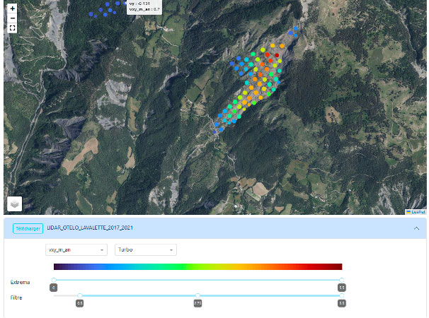
► OTELO-RISKS interface. This tool provides an online display of ground movements detected by analyzing satellite data. It superimposes the movements obtained from different sources (satellite optical and SAR, field measurements, etc.) and the issues present in the area under study. Movement is represented by dots whose color depends on the intensity of movement. © SAGE Ingenierie/Tetras Libre |
|
Objectives
- Adapting existing image analysis tools to the specific requirements of high mountain environments.
- Offer operational, modular and precise tools.
- Developing a demonstrator to visualize the effects of climate change on mountain gravity hazards.
- Raising awareness among local players about the use of these products, to better understand and anticipate the risks.
Partners
|
👉Role in the project: Methodological developments in image processing. Calculation of deformation products on study sites and qualification with soil measurements. Definition of product requirement specifications with identified customers. Promoting products to customers and developing the visualization demonstrator. Staff involved: Ombeline Méric (responsible for SAGE), Héloïse Cadet, Lionel Lorier, Pierre Bottelin |
|
👉Role in the project: Scientific support for the development of image processing analysis methods and the interpretation of results. Optimization of the processing codes developed for rapid and flexible use on computing clusters. Validation of satellite products calculated using reference data. Staff involved: David Michéa (responsible for EOST), Bastien Wirtz, Floriane Provost, Jean-Philippe Malet (advisor) |
Application site(s)
France :
- Savoie Department: Vanoise ski resorts
- Alpes de Haute Provence Department: middle and upper Ubaye valley
Data
Satellite
- Sentinel-1 and COSMO-SkyMed (CSK) synthetic aperture radar images
- Multispectral images Sentinel-2, Spot6/7, Planet CubeSAT/DOVE
Other
- In-situ sensor measurements (GNSS, extensometers, network of tacheometric prisms)
- Airborne LiDAR data
Results – Final product(s)
-
Maps and time series of ground movements detected at pilot sites using satellite image analysis
-
Inventory of new unstable areas to complement existing inventories.
-
Advanced inventories with information on object kinematics.
-
Online web service that displays the gravity instabilities inventoried in the Alps with a cursor to model the impact of climate change.
-
Awareness-raising workshops organized in the regions.
Related project(s)
The PERILS project is based on developments carried out as part of the Space Tour France 2030 / OTELO project.