

OpHySE-MoCha

Operational Hydrology from Space and modEls in the Mozambique Channel
Overview
Based on the operational implementation of research products, the SCO OpHySE project has led to the setting up of the SAGUI platform for monitoring and alerting watercourses in French Guiana, including several watercourses that are not monitored in situ and/or cross-border. With OpHySE-MoCha, the project team aims to transpose its system to the catchment areas of the Mozambique Channel, bringing together a consortium of laboratories (GET, LEGOS), private companies (HydroMatters, Pi-Geosolutions, Magellium) as well as the World Food Programme and Doctors without Borders.
- East African coastline context
From the Rovuma to the Limpopo, the watersheds along the East African coast are of major importance to the local population. The freshwater they provide is essential for food production (agriculture, fishing, etc.). But for these populations, concentrated on the coasts and along the rivers, the hazards linked to changes in the hydrological cycle of these rivers (longer low-water periods and higher temperatures, more pronounced flood peaks) are all the more numerous and significant as they can be added to the hazards linked to cyclonic risks. In these regions, the immediate risks associated with river flooding (material and human damage, water-related illnesses) are added to the medium-term risks, such as water shortages, jeopardizing the countries' agricultural capacity.
In Zimbabwe, Mozambique and Tanzania, the World Food Programme (WFP) is working with national institutions to implement anticipatory actions based on hydrological risk assessment, with the aim of reducing the impact of various events on populations. These actions would greatly benefit from the provision of near-real-time space-based hydrological observation data, as in situ observation networks are often not detailed enough for comprehensive regional monitoring.
- Objectives
Based on the platform developed as part of the OpHySE project, OpHySE-MoCha will deploy a similar platform in the catchment areas of the Mozambique Channel, including the transboundary Rovuma and Limpopo rivers (in the extreme north and south of the area respectively). Aimed at local hydrometeorological agencies and basin organizations, the visualization platform will be adapted to local issues, in particular by highlighting appropriate indicators defined with users. These indicators should highlight the impact of climate change on the basins concerned, while addressing the issues specific to them.
This will also enable us to prove the generic capacity of the methods used and their scalability, opening the door to subsequent deployments. This project therefore represents a major step forward for operational space hydrology in that, on the initiative of researchers and private companies, operational monitoring resources are being made available to the whole community (researchers, operational agencies, etc.) with a clear humanitarian scope.
- Methodology
OpHySE-MoCha uses the methods implemented in the OpHySE project and its SAGUI platform, adapted from research carried out in recent years in the OMP LEGOS and GET laboratories, particularly in terms of hydrological modelling and satellite altimetry observations of rivers for hydrology.
👉 OpHySE provides an overview of the state of catchment areas in real time, using a hydrological model fed in real time by satellite precipitation (GPM data) and whose state is constantly improved by the assimilation of spatial data (Copernicus Sentinel-3 and Sentinel-6 altimetry data). An initial estimate of future variations in flows over a five- to ten-day period is provided. This estimate is essentially based on statistical precipitation and the propagation of flows in the basins and could be greatly improved by the use of forecast precipitation fields such as global model products (GFS, ARPEGE) or EUMETSAT products over the African zone. In addition, the use of observations of flooded surfaces at different times in the hydrological cycle thanks to the Sentinel-1&2 satellites and comparison at the same dates with the heights/discharges observed or produced by the platform will make it possible to create abacuses at selected critical points, which will be used as a basis for producing hazard maps.
👉 OpHySE-MoCha will use a similar procedure to provide real-time hydrological information on the rivers bordering the Mozambique Channel. This includes the Rovuma, Lurio, Meluli, Lingonha, Licungo, Lower Zambeze, Pugwe, Buzi, Sabi and Limpopo rivers. This list of rivers may be refined during the course of the project depending on the availability of validation data and the existence of specific problems. In addition to flow data for all the rivers, specific indicators will be set up in places of special interest identified with the users. As with the OpHySE project, the tool will be based on a real-time run of the MGB model, which will be fed with the best real-time precipitation product for the area. An assessment of the available products will therefore be carried out beforehand. Each new observation from the Copernicus Sentinel-3 and Sentinel-6 satellites will be used via an assimilation scheme to correct the imperfect state of the model. Data from the SWOT satellite, particularly Nadir data, will also be used. Forecasts for different time horizons (short and medium term) will also be deployed. These forecasts will use precipitation forecasting products from global and/or regional models as inputs.
Application site(s)
Watersheds bordering the Mozambique Channel, mainly in Mozambique.
Data
Satellite
The platform is fed by a wide range of spatial data.
During the construction phase, the hydrological model is designed using mainly satellite data (terrain model, land use, drainage networks, etc.).
Dynamic data such as rainfall, meteorological data and water observations (water levels, flooded areas, etc.) from Copernicus Sentinel missions and available on the Hydroweb.next platform (supplemented, if necessary, by expert data) are also used to validate the model or estimate flows in real time.
Other
Spatial data are supplemented/validated by field data (climatology, rainfall, flow rates) if these are available over a joint period. Otherwise, these data can be used as a minimum, for example to analyze the temporal consistency of data obtained from space. Forecasts of hydro-climatic variables are based on numerical models.
Results – Final product(s)
Platform for monitoring and forecasting flows on the main rivers of the East African coast bordering the Mozambique Channel, with API service for downloading data.
|
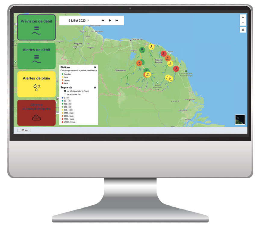
👉 While you wait for the platform to be rolled out, don't hesitate to consult SAGUI, which is freely available for monitoring French Guiana's catchment areas. |
SAGUI platform on French Guiana's rivers. © Hydromatters |
Related project(s)
SCO OpHySE