

SCOFrance
2Online demonstrators
PartnersHytech-imaging, OFB, PNRA, IUEM, IRISPACE, CNES
Useful linkProject page
Key wordsCoastal vegetation, intertidal zone, high tide, low tide, seasonal evolution, change detection
Littosat is fully operational and can be transposed to coastal monitoring
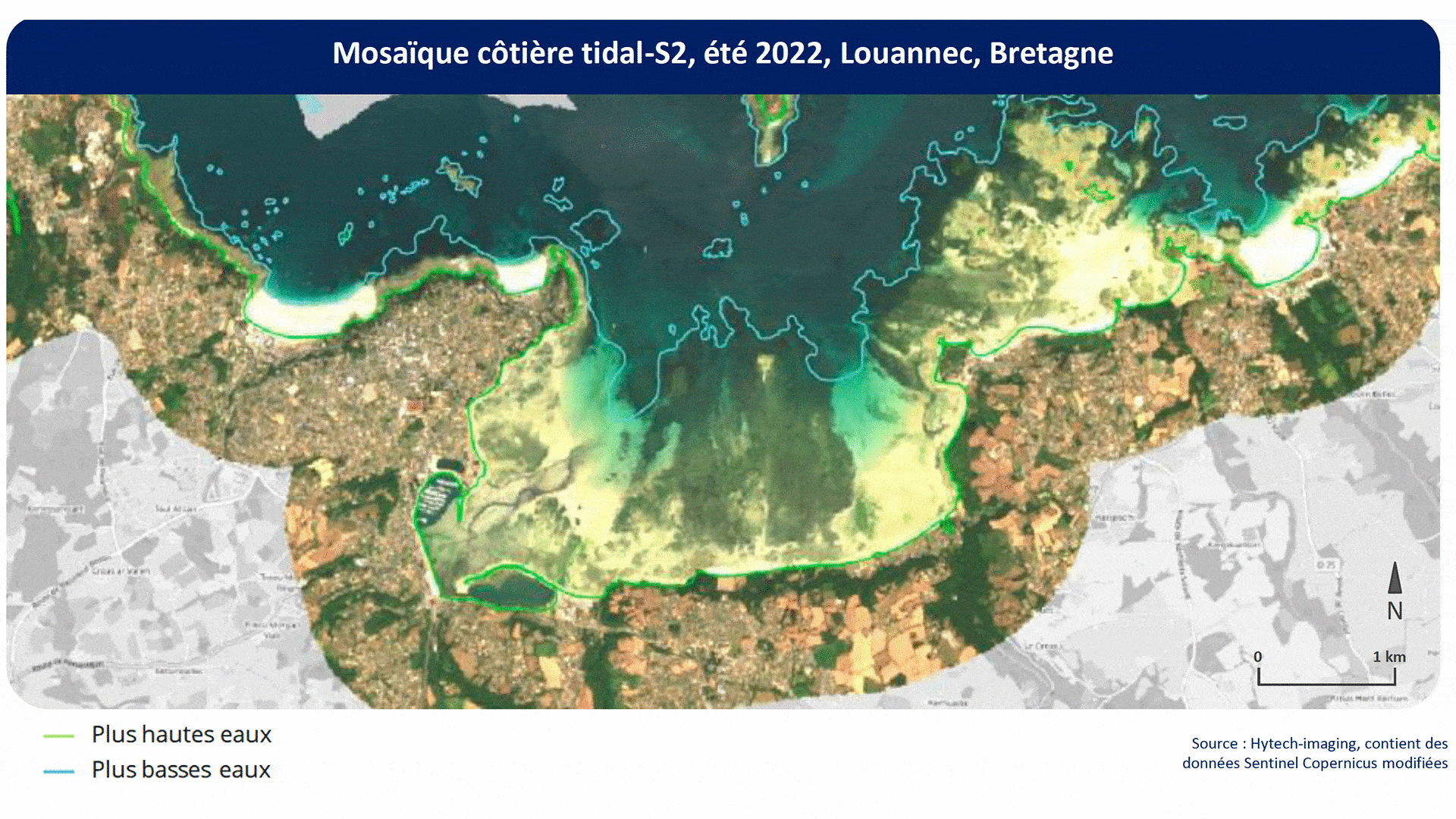
Coastal ecosystems are particularly affected by climate change. To monitor them in near-real time and see how they are changing, Littosat has developed a unique tool that generates a continuous seasonal coastal mosaic at high and low tide, using the best Sentinel-2 satellite images, from which vegetation presence indicators are calculated. The results are displayed on an online platform where users can easily visualize the vegetation of the intertidal zone, including at low tide, and maps of seasonal changes (gain or loss of vegetation cover).
Designed with and for users, this interface can incorporate other useful data regularly used by managers, such as the boundaries of Natura 2000 zones, regional and marine nature parks, land-sea boundaries, etc., as well as bathymetric data and habitat inventories such as seagrass beds, etc.
"User involvement has grown throughout the project. There has been a real educational transfer, with a better understanding of the need for us, the service provider, and a better understanding of the satellite's potential, with its advantages and limitations, for them." Marie Jagaille, Hytech-imaging
2 demonstrators and a new user
"In particular, the SCO has enabled us to completely overhaul the interface so that it better meets the requirements of data distribution with a seasonal time step," explains Marie Jagaille, project manager for Hytech-imaging
|
After intensive discussions with pilot users, two demonstrators have been implemented in Brittany and Normandy. Motivated by the direct access to online visualizations, the Gulf of Lion Marine Natural Park contacted Hytech-imaging. It now has its own interface via a three-year subscription, with the intention of using it in particular for decision support and to run its public consultation meetings. |
Rapidly replicable |
|
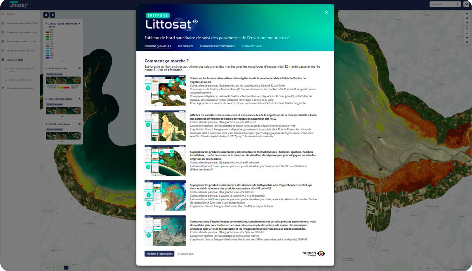
The Littosat interfaces welcome the user with a window presenting and using the various functions available. © Hytech-imaging |
|
Find out more about Littosat, including a video demonstration, on the project page
The story is just beginning
Thanks to its infrastructure, which is designed to accommodate future APIs, Littosat can adapt to each user with tailor-made services, in the knowledge that this new data is far from having delivered its full potential. "The SCO has also enabled us to develop monitoring products to go even further, and ultimately generate a continuous vegetation indicator whatever the tide. Other avenues, such as the integration of satellite (Bathysat) or airborne (Litto3D) bathymetric products with seagrass inventory data, look very promising for linking morphology and substrate to the development of different coastal habitats. We have held a user workshop on this subject, and we will be continuing our work", Marie Jagaille is delighted to report.
The next steps are to extend Littosat, in particular as part of a collaboration with Mercator Ocean International on extending Copernicus Marine services to the coastal zone, and to federate a larger community of users, initially by deploying LittoSat in France. At the same time, Hytech-imaging is continuing its innovation work in close collaboration with users and experts (IUEM, OFB, marine nature parks, etc.) in order to develop robust indicators for monitoring the ecological status of coastal habitats and contributing to the Framework Directives*.
* Water Framework Directive WFD, Marine Strategy Framework Directive MSFD, Nature Restoration Regulation NRR