

IRRITRACK

Estimating Current and Future Agricultural Irrigation Water Use in China
Overview
Irrigation is crucial for agriculture, consuming over 70% of global water. In China, it covers 50% of farmland but produces 75% of grain. However, overuse of water surpasses local renewable resources, leading to environmental issues like groundwater depletion and soil salinization. Climate change exacerbates these challenges by altering precipitation and increasing temperatures, making irrigation even more vital for food security. Traditional methods of estimating irrigation water use are resource-intensive and often inaccurate due to regional differences. Advances in satellite remote sensing offer a more efficient approach, but uncertainties remain due to the complex relationships between water use and environmental variables, and the limitations of current models.
The IRRITRACK project aims at estimating irrigation water use for major crops in China and offering projections under future climate scenarios, providing valuable insights for decision-makers to better manage water resources in a changing climate.
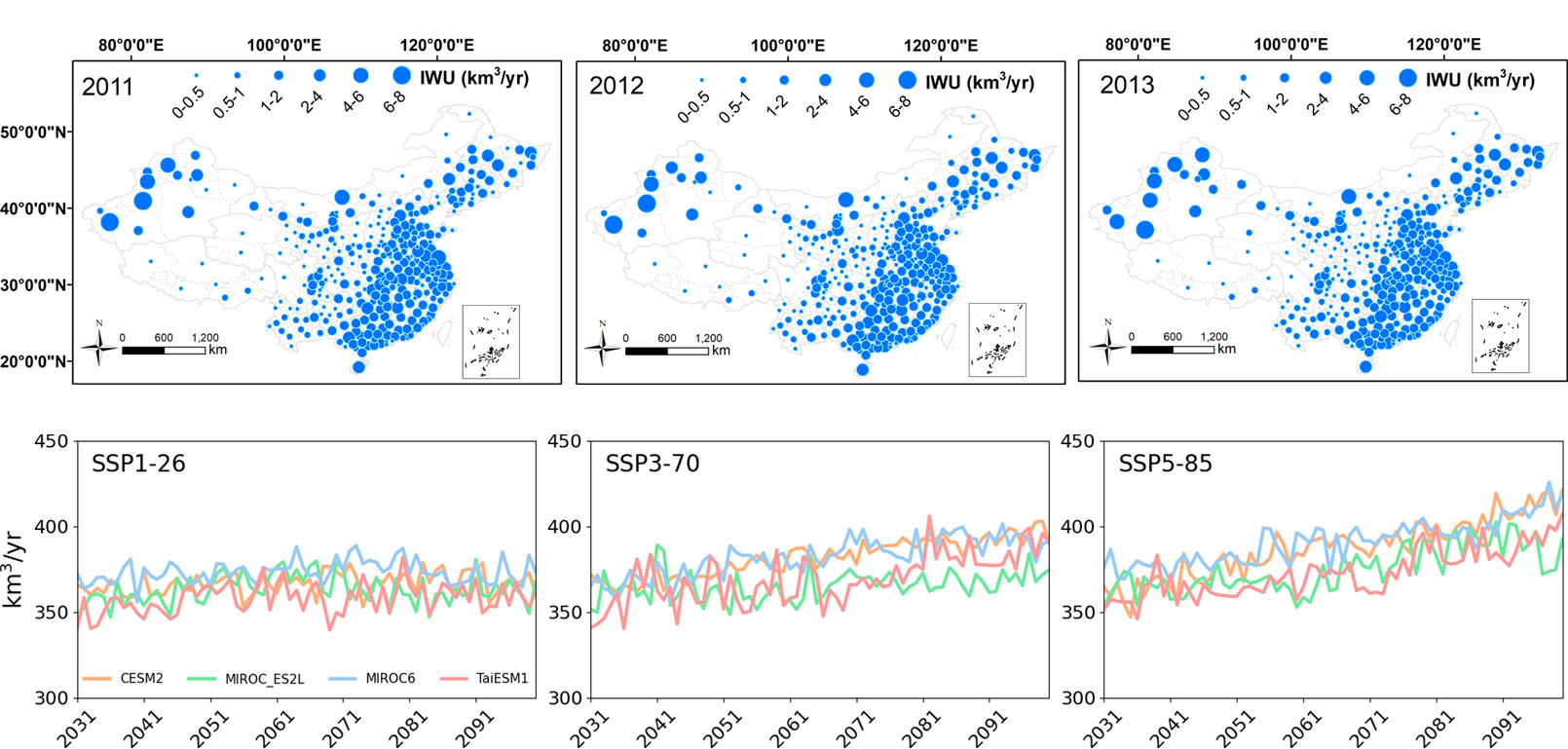
Irrigation water use in China from 2011 to 2013 (top), and projected irrigation water use from 2031 to 2100 under three different forcing scenarios (bottom). © The Aerospace Information Research Institute, Chinese Academy of Sciences
Methodology
IRRITRACK integrates process models with ensemble machine learning algorithms and remote-sensing data to accurately calculate irrigation water use.
Application site(s)
IRRITRACK is implemented at both city and provincial scales across mainland China.
Data
Satellite
- Fengyun-3 (FY-3) data (polar-orbiting meteorological satellites)
- FY-3G (precipitation monitoring)
- FY-3A
- Global Precipitation Measurement (GPM) satellite data
Other
- Meteorological data (from the China Meteorological Administration)
- Meteorological parameter simulations from Earth System Models (CMIP6)
- Historical annual irrigation water data (from the Ministry of Water Resources of China)
Results - Final product(s)
The IRRITRACK project provides a tool/service that efficiently delivers estimates of irrigation water consumption for three major crops (i.e., rice, wheat, and maize) across China’s regions. Specifically, this project provides an extensive irrigation water dataset at the administrative city scale spanning from 2001 to the present in China.
This project extends its scope to predict the evolving trends of irrigation water at the provincial scale in China over the next 70 years under various carbon emission scenarios. This forward-looking analysis provides a grounded foundation for policymakers to craft adaptive agricultural water resource management strategies in response to climate change.
References
Kai Liu, Yong Bo, Xueke Li, Shudong Wang, and Guangsheng Zhou. Uncovering current and future variations of irrigation water use across China using machine learning. Earth’s Future 12, no. 3 (2024). https://doi.org/10.1029/2023EF003562
Related project(s)
- SCO EO4AgriWater (mainland France and New Caledonia), which merges the results and methodologies of three other SCO projects to provide a synthetic drought/irrigation/water indicator.
- SCO IRRISAT (Morocco), which combines two complementary approaches to estimating plant water consumption and requirements, to provide results at farm plot, irrigated sector and watershed scales.