

HydroLake

Lake Level Change Monitoring and Prediction
Overview
Sentinels of climate change, lakes play a crucial role in the water cycle, ecosystems and climate patterns. Like Qinghai Lake, China's largest lake, which is crucial for maintaining the ecological security of the Tibetan Plateau and acts as a natural barrier against the eastward spread of desertification.
While it is essential to monitor its evolution, the high cost of field observations makes it difficult to obtain long-term, continuous data, a common issue to many lakes around the world. Moreover, predicting lake levels over the long term is challenging due to inconsistencies in multi-source data and the lack of integration between hydrological models and climate scenarios.
|
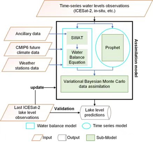
In this context, the HydroLake project, implemented in the Yellow River basin, aims to enhance the prediction of lake levels under climate change conditions by assimilating hydrophysical models with spaceborne laser altimeter observations. The model is expected to take into account both the effects of future climate change by CMIP6-SWAT climate-driven projections and recent lake level by latest ICESat-2 lake level observations on future lake levels, making it more accurate in predicting both short-term values and long-term lake level trend. ► Schematic diagram of long-term lake level trend prediction. © The University of Chinese Academy of Sciences |
|
Thanks to this information, which are essential for understanding hydrological processes in a changing environment, HydroLake will enable timely and effective decision-making in water management and environmental protection.
As the model is based on satellite remote sensing observations, it is expected to have the potential to be applied to any lake and extended worldwide.
Application site(s)
Qinghai, China
Data
Satellite
- ICESat-2 (Ice, Cloud and land Elevation Satellite)
Other
- Meteorological data from the Meteorological Observation Center of China Meteorological Administration
- Global climate model (GCM) projections from the WCRP Coupled Model Intercomparison Project Phase 6 (CMIP6)
- Harmonized world soil database (HWSD v1.2) from FAO and IIASA
- Terrain data from Geospatial Data Cloud of China
Results - Final product(s)
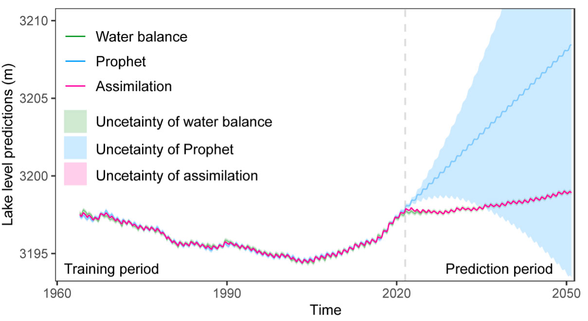
The figure below shows our predicted changes in lake levels up to 2050, which can represent variations in water volume.
The code and results can be shared upon request.
|
► Long-term lake level trend prediction of Lake Qinghai. Predictions of water balance, prophet and the assimilation models indicate that lake levels of Qinghai Lake will continue to rise by 2050. According to the assimilation model and the water balance model, lake levels will rise at a rate of 3.7 cm/year from 2022 to 2050 under the SSP2-4.5 scenario. © The University of Chinese Academy of Sciences |
|
References
Liu, C., Hu, R., Wang, Y., Lin, H., Wu, D., Dai, Y., ... & Hu, Z. (2023). Integrating ICESat-2 laser altimeter observations and hydrological modeling for enhanced prediction of climate-driven lake level change. Journal of Hydrology, 626, 130304.
Related project(s)
SCO StockWater