

GEODES centralizes access to satellite data in France
|
To exploit the potential of space data, the SCO France community, and more widely the entire national ecosystem, must be able to rely on simple, clear access to data.
► Representing almost 55% of the satellite data used by SCO France projects, Sentinel data is free and covers all the surfaces and dynamics of the planet every 5 to 12 days, down to 10 meters resolution. Thanks to the DINAMIS system, VHR data (up to 50 cm resolution), mainly from SPOT and Pléiades, make up more than a third of the data used by SCO France projects. |
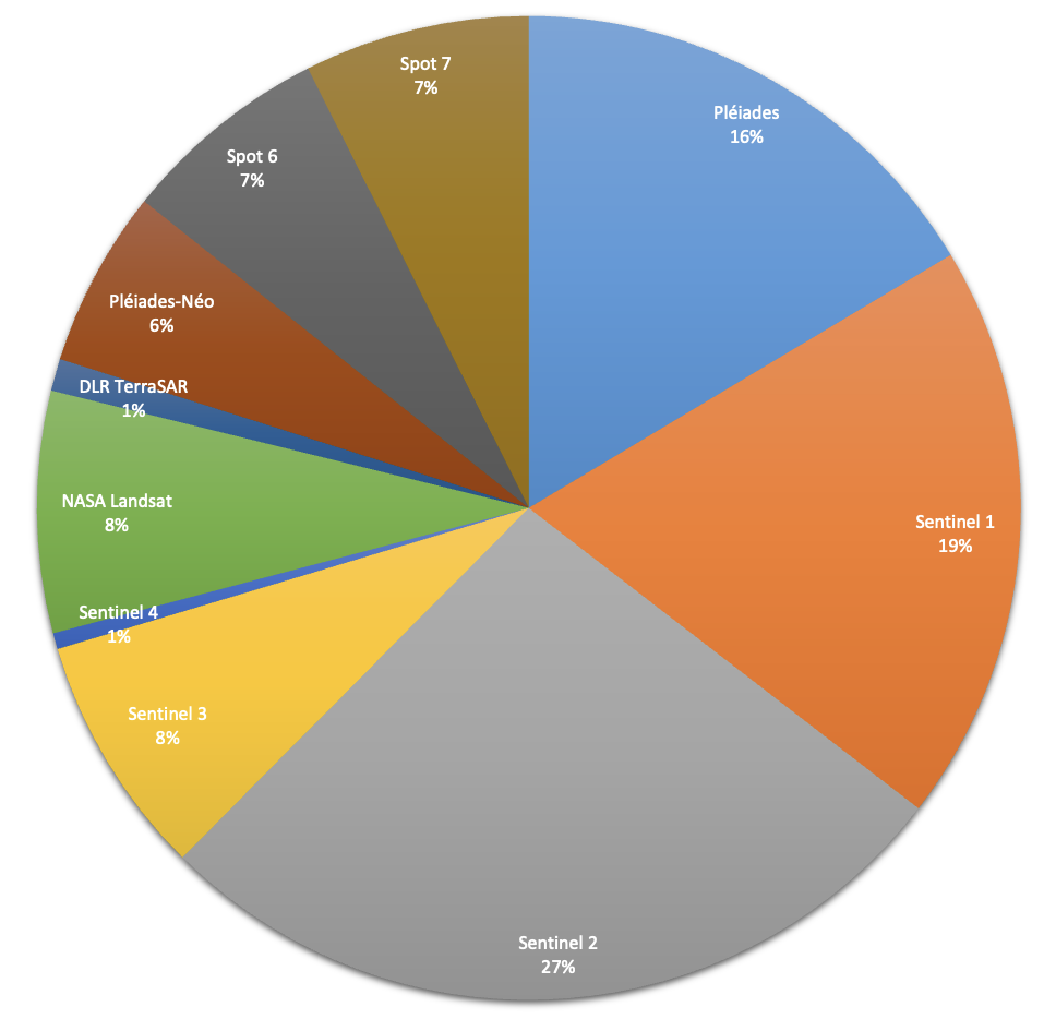
Satellite data used by SCO France projects |
CNES, the French space agency leading SCO France, is responsible for making this data available through the GEODES portal.
The result of several years' preparation, GEODES is the successor to PEPS, the operating portal for Sentinel products, which bowed out on 17 January 2025 after 10 years of loyal service (see article on GEODES, in French). Users can rest assured: all PEPS data and functions will be migrated to GEODES, ensuring continuity of service, but that's not all.
 , designed for you
GEODES has therefore become THE French portal for accessing Earth Observation satellite data from CNES and the Copernicus programme, the aptly named Sentinels.
👉 Users can search by theme or directly on the GIS mapping interface. This already includes Sentinel-1&2, Venus, Spot, Landsat and OSO (land cover) data and products, as well as vegetation, radiation, water and continental surface products.
👉 GEODES also acts as a gateway to the DATA TERRA research infrastructure and its data centers, to which CNES also contributes: AERIS (atmosphere), Form@Ter (solid Earth), ODATIS (ocean) and THEIA (continental surfaces).
👉 For those who need very high resolution data, GEODES can point you in the direction of DINAMIS, a cross-disciplinary component of DATA TERRA, which offers a range of commercial data, in particular from Pleiades and SPOT imagery.
🎥 To find out more, launch the replay of the DINAMIS presentation (in French) specially devised for the SCO community at the 5th Quarterly Projects Meeting to explain the conditions of use and the workings of this system.
"GEODES is a genuine digital engine for promoting the use of satellite data, giving CNES a lasting position in the exploitation of Earth observation data. More broadly, the platform is helping to meet new challenges (digital twins, artificial intelligence, etc.) in concert with the French and European communities." François Jocteur-Monrozier, CNES Deputy Director for Missions, Earth Observation Data and Downstream Applications
|
New collections will gradually be added to the catalogue, including the remarkable Spot World Heritage archives, so don't hesitate to explore it, as well as the Support menu, which offers various tutorials on how to use GEODES to suit your needs. Finally, GEODES is not just a data access portal: you'll find a wealth of information and news on the world of Earth Observation and its innovations, as well as, for the more experienced users, the possibility of requesting processing on demand or even using advanced interactive processing functions. |
The SCO, a GEODES benchmark While SCO projects are potential users of GEODES, SCO France is a genuine partner. In the Discover > Tools and services menu, the demonstrators listed are those implemented by SCO projects! |
Moral: there's only one thing left to do 👉 click to go to GEODES
💡Did you know? You can find all these features, as well as those of Copernicus, at any time in the SCO Resources Menu, item Access to satellite data and products.