DEW-PH
Drought Early Warning in the Philippines
Overview
The agricultural sector in the Philippines is highly vulnerable to climate risks, particularly the increasing frequency and intensity of droughts. The DEW-PH Project aims to enhance drought monitoring and forecasting by utilizing satellite-based data and building on the results of previous research and development initiatives, particularly the Drought and Crop Assessment and Forecasting (DCAF) Project that was co-implemented by the University of the Philippines – Institute of Environmental Science and Meteorology (UP IESM), Department of Science and Technology – Philippine Atmospheric, Geophysical and Astronomical Services Administration (DOST-PAGASA), and the Department of Agriculture – Bureau of Soils and Water Management (DA-BSWM).
The project will generate agricultural drought maps for both monitoring and forecasting purposes, using data derived from satellite-based rainfall, land surface temperature (LST), and normalized difference vegetation index (NDVI). These maps will be thoroughly assessed and analyzed to improve the understanding of drought patterns.
The findings from DEW-PH will serve as support to form the basis for developing a national policy on early warning and monitoring of agricultural drought. This will be done in collaboration with other government agencies through a series of workshops and consultations. By advancing knowledge of climate change risks in agriculture and creating more effective monitoring and forecasting systems, DEW-PH will contribute to enhancing drought resilience and sustainability in the country's agricultural sector.
Application sites(s)
The Philippine land mass focusing on its agricultural lands.
Data
Satellite
- Global Precipitation Measurement (GPM) satellite: Rainfall data
- Terra satellite (Moderate Resolution Imaging Spectroradiometer – MODIS) :
- Land Surface Temperature (LST)
- Normalized Difference Vegetation Index (NDVI)
Other
- Oceanic Niño Index (ONI) records and forecasts
- Drought damage reports from the Philippines’ Department of Agriculture
- Ground-observation data: Synoptic stations from DOST-PAGASA and the AWS of DA-BSWM
Results - Final product(s)
The project focuses on producing monthly monitoring maps that delineate regions impacted by agricultural drought. The final products of the DEW-PH project are in the form of intuitive monitoring and forecasting maps that showcases the following:
- Monthly monitoring maps that delineate regions impacted by agricultural drought.
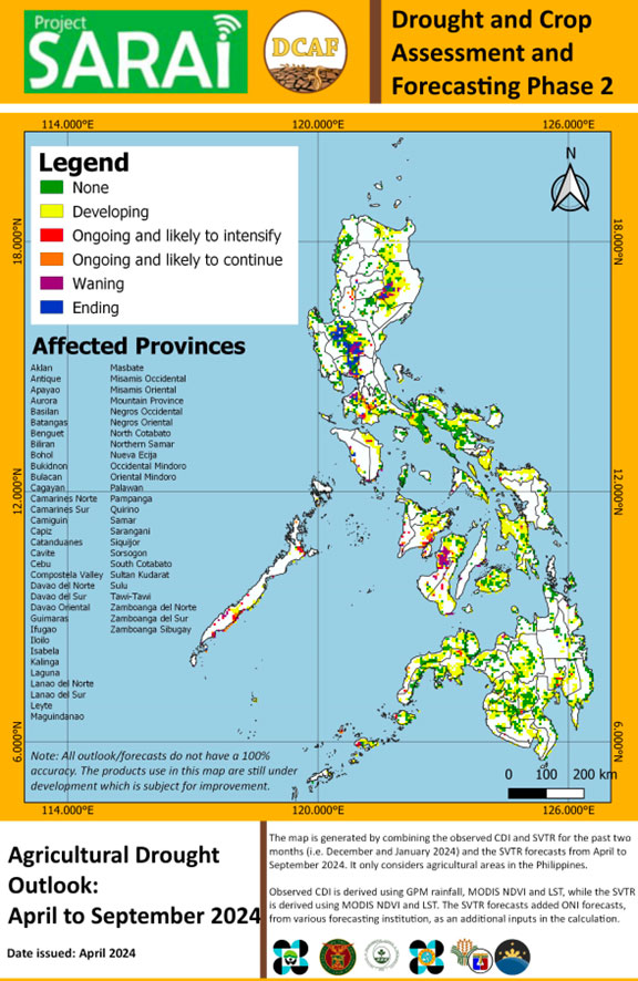
- Outlook map combines monitoring and forecasting maps into one infographic, tagging areas that are experiencing or will experience drought for the next six months.
Moreover, an automated system (e.g., a dashboard) will be set up at a workstation in partner agencies, allowing them to automatically generate products that will then be sent to other relevant government agencies. This ensures the seamless operation and reliability of the system, contributing to the ongoing success of the project's objectives.

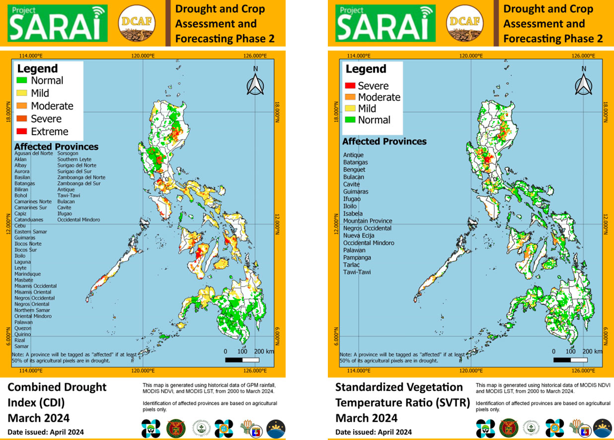
▲ The satellite-based Combined Drought Index (CDI) and Standardized Vegetation Temperature Ratio (SVTR) for March 2024 showing areas potentially affected by agricultural drought. © Philippine Space Agency (PhilSA)
|
▶︎ The Agricultural Drought Outlook from April to September 2024 was initialized using data available from 2000 to March 2024. Outlook is a derived of observed and forecasted drought. © Philippine Space Agency (PhilSA) |
|
References
-
Characterizing the drought development in the Philippines using multiple drought indices during the 2019 EL NIÑO by Gay Jane Perez, Odette Enricuso, Kimberly Manauis, Michael Angelo Valete published in ISPRS Annals of the Photogrammetry, Remote Sensing and Spatial Information Sciences, 3, 463-470. https://doi.org/10.5194/isprs-annals-V-3-2022-463-2022
-
Forecasting and Monitoring agricultural drought in the Philippines by GJ Perez, M Macapagal, R Olivares, EM Macapagal, JC Comiso published in The International Archives of the Photogrammetry, Remote Sensing and Spatial Information Sciences, 41, 1263-1269. https://doi.org/10.5194/isprs-archives-XLI-B8-1263-2016
-
Assessment of Combined Drought Index (CDI) for Drought Monitoring in the Philippines During the 2018-2019 El Nino by MA Valete, PD Ang, A Veloria, GJ Perez published in the Asian Conference on Remote Sensing 2022 at Ulaanbaatar, Mongolia. https://philsa.gov.ph/wp-content/uploads/2022/10/ACRS2022Valete_etal_full_paper_Sept10_v2.pdf
Related project(s)
SARAI (Smarter Approaches to Reinvigorate Agriculture as an Industry in the Philippines), an action-research program, funded by the Department of Science and Technology – Philippine Council for Agriculture, Aquatic and Natural Resources Research and Development (DOST-PCAARRD), working towards reducing climate risks by providing agricultural stakeholders with site-specific crop advisories.


