

CASCADES
.")
Automatic processing chains for the monitoring and characterization of continental surface waters
Overview
Context
Water is essential to life and to the various ecological and social systems. Unfortunately, water is one of the natural resources most affected by climate change, with increasingly intense hydro-meteorological extremes (floods, droughts, etc.) and growing societal demand. To help manage this fragile resource, it is vital to be able to assess and monitor its availability on a regular basis, but also to be able to track its trajectory over time to better understand the impact of global change on it.
Surface water (lakes, rivers, flood plains, etc.) is an important link in the availability of water resources that must be monitored to better understand and manage the consequences of climate change. These surface water resources provide people around the world with essential ecosystem services such as electricity generation, irrigation, drinking water for humans and livestock, and space for fish farming and fishing.
Objectives
In this context, the CASCADES project proposes to automate end-to-end processing chains for Earth observation satellite data, in particular Sentinel-1 and 2 (S-1 and S-2), in order to provide surface water products. These products will include surface water extent maps, and for periods of high water, water level maps generated by merging water extent maps with the Copernicus digital elevation model (CopDEM). All the products generated by the project will be made available via an interactive platform co-constructed with identified users. We thus propose to develop the first tool to provide recurring surface water products for sites in the South.
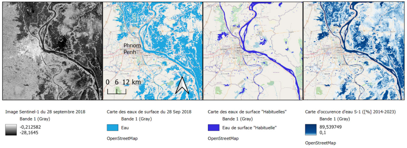
▲ Example of CASCADES products on Mekong floodplains around Phnom Penh (Cambodia): from left to right, S-1 image from 28 September 2018 and its associated surface water map, map of "usual" water areas and water occurrence map from multi-temporal analysis. © Copernicus Sentinel imagery, Fonds de carte : OpenStreetMap, Traitement : Renaud Hostache
Methodology
The satellite image processing chains will be based on several state-of-the-art automatic algorithms for mapping water areas and water levels, developed and frequently used by members of the consortium (e.g., Matgen et al. 2011, Giustarini et al. 2013, Alexandre et al., 2020, Johary et al. 2023, Ayoub et al. Submitted). They will enable one to process all the S-1 and S-2 images automatically (or a subset, at the user's discretion) over a pre-selected area of, thereby providing temporal monitoring of surface water resources. Given the important cloud cover during wet season at some of the sites, the tool will focus on S-1 radar sensors but will also be able to integrate S-2 optical images.
The CASCADES project proposes two complementary approaches:
-
a "static" approach aimed at providing products over the entire temporal depth S-1. In this case, the S-1 time series will be systematically processed beforehand to produce maps of water areas for each image available over the zone. Project users will thus have instant access to the time series of surface water maps via the project platform.
-
a "dynamic" approach in which the user can select an area of interest within the project study sites, and a time range within which to obtain maps of water areas for each Sentinel image. This second approach will also enable the archive of surface water maps to be regularly updated with recent Sentinel acquisitions.
The proposed S-1 image classification approach will combine an analysis of the SAR backscatter of the processed image, but also a multi-temporal analysis and change detection to reduce poor detections (shadows, roads, tarmac, etc.) and generate maps of 'usual' water areas (on a seasonal or even monthly basis). Thus, in addition to maps of 'instantaneous' surface water areas (at the time of SAR image acquisition), CASCADES will provide average seasonal water areas thanks to the analysis of multi-year Sentinel image series. In addition, we propose to implement statistical approaches (e.g., Giustarini et al, 2016) to characterize classification uncertainties and thus be able to provide users with confidence indices for water area maps. Based on the time series of water area maps, we propose to generate, among other datasets, over the Sentinel lifetime or a given year, maps of occurrences and annual duration of submersion, as well as hydrological (surface) state indices per area of interest such as the area of water surfaces and its comparison with a standard state at the same season (based on seasonal water surface maps). The choice of relevant indices for users will be discussed with them during the workshops.
Application site(s)
We will setting up this processing chain and the associated platform over 6 large, contrasting study areas :
- Cambodia: Tonle Sap lake basin and plains of the upper Mekong delta
- Madagascar (with a focus on the Betsiboka basin)
- Brazil: several flood plains in the Amazon basin (focus on the Curuai)
- Bolivia: hydrological system of Titicaca, Poopó, Desaguadero, Salar (TDPS) on the Bolivian altiplano
- Ecuador: Guayas basin, [-2,169, -79,868]
- Niger: the Goulby Maradi and Goulby N'Kaba rivers
These sites, which are regularly affected by hydrometeorological extremes exacerbated by climate change and where water resources are central to human societies and ecosystems, are representative case studies of water-related issues around the world.
Data
Satellite
- Sentinel-1
- Sentinel-2
- SWOT and other sensors to validate cards and products
Other
- OpenStreetMap
- In situ data from partners to validate maps and products
Results – Final product(s)
In the 6 study areas, the project will supply the following products (this list of products may be extended according to the recommendations and needs formulated by users):
- Archive of surface water extent maps for the duration of Sentinel-1 and 2.
- Monthly and seasonal maps of "usual" water areas.
- Surface water occurrence maps.
- Archives of water level maps during periods of flooding.
- Indications of the exceptional nature of current events.
👉These products will be directly viewable and retrievable via a dedicated online interface. Co-constructed with local users, this CASCADES dissemination platform will provide indices relevant to needs as well as the ability to produce knowledge on the fly over an area and period chosen by the user.
References
- P. Matgen, R. Hostache, G. Schumann, L. Pfister, L. Hoffmann & H.H.G. Savenije. Towards an automated SAR-based flood monitoring system: Lessons learned from two case studies. PCE, 36(7-8):241-252, 2011, https://doi.org/10.1016/j.pce.2010.12.009
- L. Giustarini, R. Hostache, D. Kavetski, M. Chini, G. Corato, S. Schlaffer and P. Matgen, Probabilistic flood mapping using Synthetic Aperture Radar data, IEEE TGRS, 54(12): 6958- 6969, 2016, https://doi.org/10.1109/TGRS.2016.2592951
- L. Giustarini, R. Hostache, G.J.-P. Schumann, P. Matgen, P.D. Bates and D.C. Mason. A change detection approach to flood mapping in urban areas using TerraSAR-X. IEEE Transactions on Geoscience and Remote Sensing, 51(4):2417-2430, 2013, https://doi.org/10.1109/TGRS.2012.2210901
- C. Alexandre, R. Johary, T. Catry, P. Mouquet, C. Révillion, S. Rakotondraompiana, & G. Pennober. A sentinel-1 based processing chain for detection of cyclonic flood impacts. Remote sensing, 12(2):252, 2020, https://doi.org/10.3390/rs12020252
- R. Johary, C. Revillion, T. Catry, C. Alexandre, P. Mouquet, S. Rakotoniaina, G. Pennober, S. Rakotondraompiana. Detection of Large-Scale Floods Using Google Earth Engine and Google Colab. Remote Sensing, 2023, 15(22):5368, https://doi.org/10.3390/rs15225368
- V. Ayoub, R. Hostache, P. Matgen, Marco Chini, R.-M. Pelich, C. Delenne. Estimating flood depth from space: an automatic method based on satellite flood imagery and topography data, RSE, Submitted
Related project(s)
- In Cambodia, the SWIFT project (ANR, 2024-2028), C. Heng's thesis (BGF/AfriCam, 2023-2026), and the deployment of KHEOBS
- In Brazil, the BONDS (Belmont Forum and BiodivERsA, 2020-2023) and SABERES (BNP Paribas Foundation, 2020-2025) projects
- In Bolivia, the WASACA project (Agropolis Foundation, 2021-2024) and the thesis by P. Pacheco Mollinedo (IRD/Wasaca, 2022-2025)
- A forthcoming thesis in Ecuador
- In Ecuador and Cambodia, the CNES post-doctorate of C. Normandin, and the WHYGHGS project (CNES SWOT-ST, 2024-2027)
- In Madagascar, the Cimopolée project (SCO/CNES, 2022-2024) and the theses of M. Ranaivoson (Région Réunion, 2024 - 2027) and J. Rosa (ERDF, 2022-2025)