CACAO
CArbon Credit AI tools based on earth Observation
Overview
Climate change is a global problem that could generate more than USD 1,000 Billion in economic damage by 2050: increasing CO2 capture capacity is an imperative that can no longer be postponed. In addition, companies, in order to be more sustainable, to improve Corporate Social Responsibility and as part of new ESG (environmental, social and governance) plans, need to reduce their environmental footprint by purchasing carbon credits to offset their emissions and to pursue net zero emissions targets.
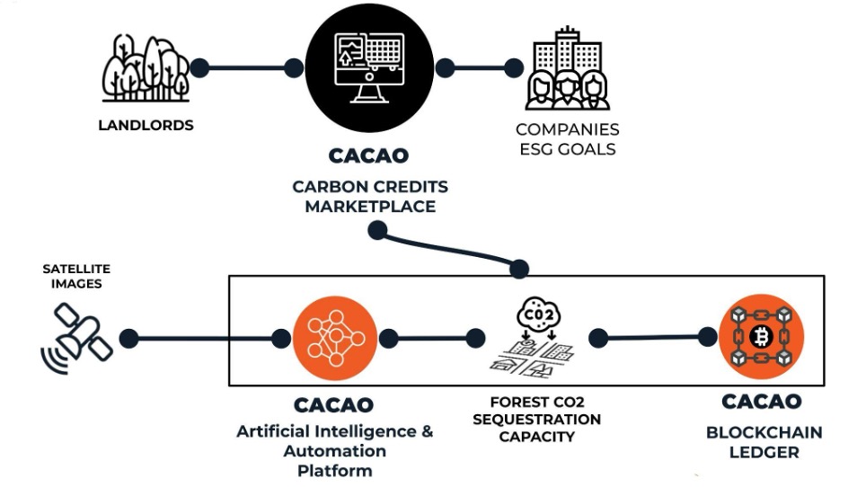
CACAO is an innovative platform that enables carbon-credit trading on a voluntary basis through the integrated management of the service cycle, from the analysis and quantification of the CO2 sequestered by a forest area to the management of the exchange between landowners and private companies interested in improving its environmental footprint.
To achieve this, CACAO aims to create a marketplace to connect supply and demand of carbon-credits based on the integrated use of remote sensing and artificial intelligence-based image analysis to accurately measure the carbon sequestered from forest areas. As part of the tokenization* of the information, a low energy blockchain ensures maximum transparency of the information provided.
* A way for companies to protect sensitive data by transforming it into non-sensitive data known as tokens.
Forest management and carbon credits
In the context of forest management, the main source of a landowner's revenue is the sale of wood from the felling of trees. This often makes the management of the area not fully profitable and leads many owners to deforest in order to use the land for other purposes (especially if there are no restrictions). The possibility of selling the CO2 capture capacity of the trees on the voluntary carbon credit market can generate for the owners an additional and recurring revenues (as they are renewed every year). Making the activity economically sustainable would also help to reduce the deforestation phenomenon in Europe (and especially in developing countries in the near future).
However, alternatives to purchasing carbon credits through a government-regulated market such as the EU Emissions Trading Scheme (ETS) are still in their infancy and not fully accepted by the market.
The main problems, defined through a deep interlocution with the involved stakeholders, are:
- Reduced transparency between the source of purchase and the source of sequestration: buyers of carbon credits want to be sure that the seller actually has the "carbon sequestration" capacity they put up for sale, that this value has been certified by a third party, and that there are no redundant transactions on the same credits.
- Lack of a secure instrument, especially for certifiers, that avoids double counting of credits (unregulated intangible asset)
- Operational complexity to calculate the amount of carbon that can be sequestered by each forest area with an adequate level of detail. Often it is necessary to carry out surveys in areas that are difficult to reach, with additional costs for the landowner. The lack of an "automatic" method for calculating carbon credits makes the model difficult to scale globally.
Solution👉 CACAO is the solution that seeks to efficiently and effectively solve the problem of the voluntary carbon credit market, with a solution capable of rapidly scaling up from the Italian market (where validation will be carried out) to the European and global markets thanks to the use of satellite remote sensing technologies. The CACAO tool will help the company to keep under control the effective implementation of forest plans from the point of view of the variation of carbon sequestration. |
|
Application site(s)
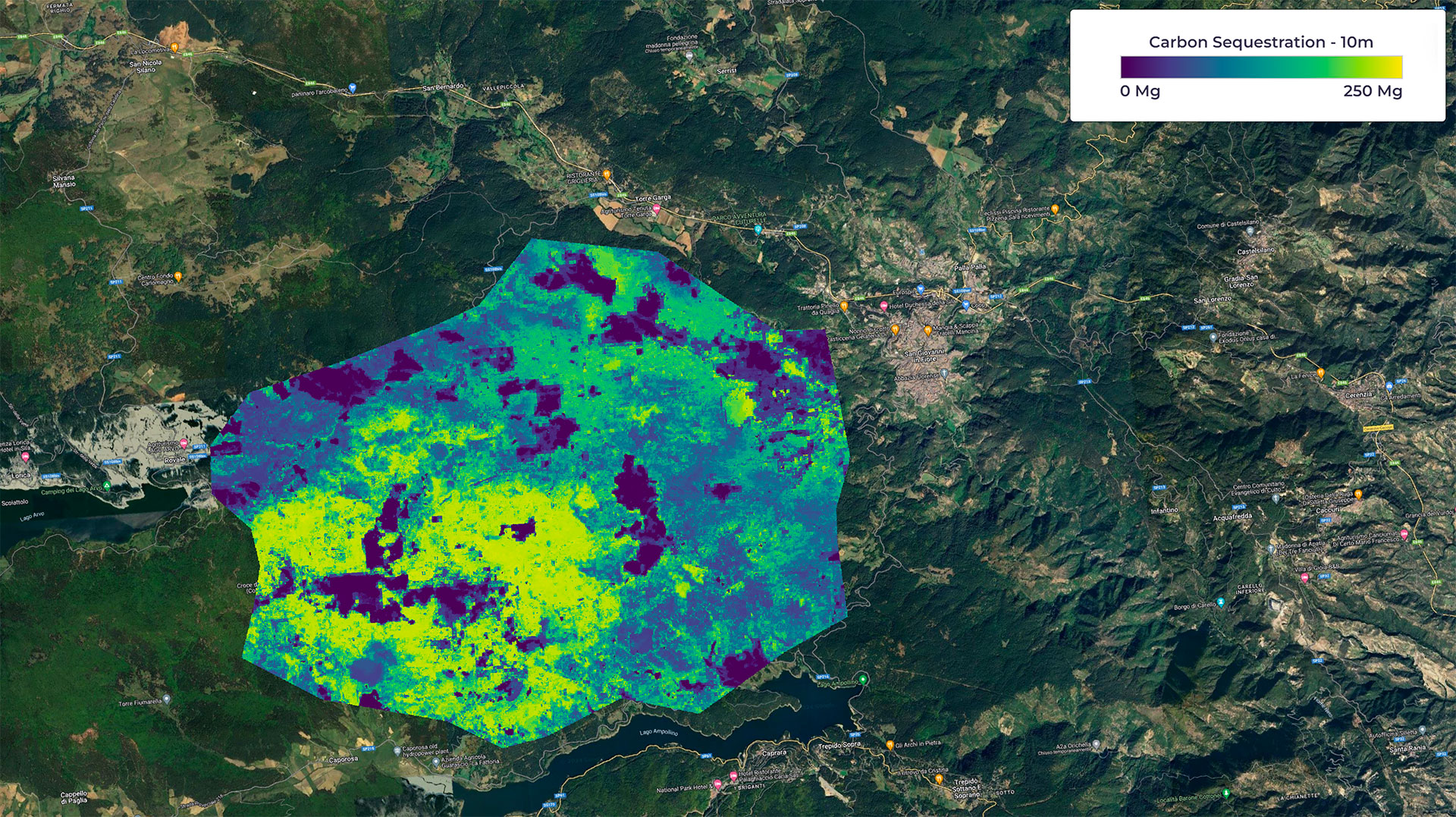
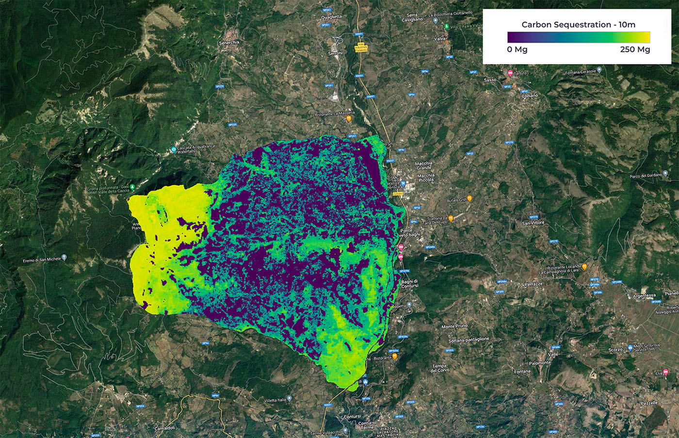
CACAO was born from years of preparatory scientific work. The prototype phase of the project is in Italy in the areas of the Campania region and the central Calabria region.

Carbon index in the forest area of Central Calabria. The gradation of colours makes it easier to interpret the spatial distribution of the carbon sequestration capacity of the areas studied: violet indicates values close to zero Mg (megagrams) of sequestered carbon, and at the other extreme, yellow represents the highest values. © Euro.Soft – Latitudo40
Data
Various types of data are needed to create the maps of the CACAO project. In particular, data on forest species and structural characteristics such as tree height, but also biomass parameters were used as ground truth data. The spatial resolution of very high-resolution optical satellite sensors makes it possible to map forests at a fine scale and at a lower cost than field observations or aerial laser scanning.
Satellite
Sentinel-2
Other
Lidar data
Results - Final product(s)
Thanks to an online mapping platform, CACAO will provide forest owners with the information necessary to monitor forest management interventions in terms of carbon footprint, converting them into carbon credits. At the same time, it will provide the free market with the possibility of purchasing certified carbon credits and thus offsetting their emissions.


