

SCOFrance
2 very different townsRennes (France) and Presidente Prudente (Brazil)
PartnersFrance : LETG, ALKANTE, CNES
Brazl : UNESP
Useful linkPresentation of the project
Key wordsRennes, Brazil, UHI, urban temperatures, connected sensors
ALTELYS, combating urban heat islands
While the phenomenon of urban heat islands (UHI) is increasing in the context of global warming, it is primarily due to urban materials that store heat throughout the day and release it at night, reducing the cooling effect at night. To support the territorial and energy transition of urban buildings, the ALTELYS project aims to combine automatic in situ measurements and satellite data, with the novelty of taking into account both exterior and interior measurements of buildings to eventually deliver online mapping of UHI in real time. The project is being led by the LETG Rennes laboratory and ALKANTE company.
Methodology in brief
- Develop the system in two cities, each with around 220,000 inhabitants, to take account of climatic and topographical differences: Rennes (France, altitude 20-70 m) and Presidente Prudente (Brazil, altitude 475 m).
- Monitor urban indoor/outdoor temperatures in real time.
- Combining satellite imagery and in-situ measurement stations.
- Characterize the behavior of built heritage in relation to UHI.
- Deliver the results via an online mapping platform, with indicators and an alert function.
To implement its project, the team had to carry out two key stages: installing connected sensors at Presidente Prudente (Rennes already has a network of in situ measurements) and gathering the needs of future users.
Installation of connected sensors in Brazil
|
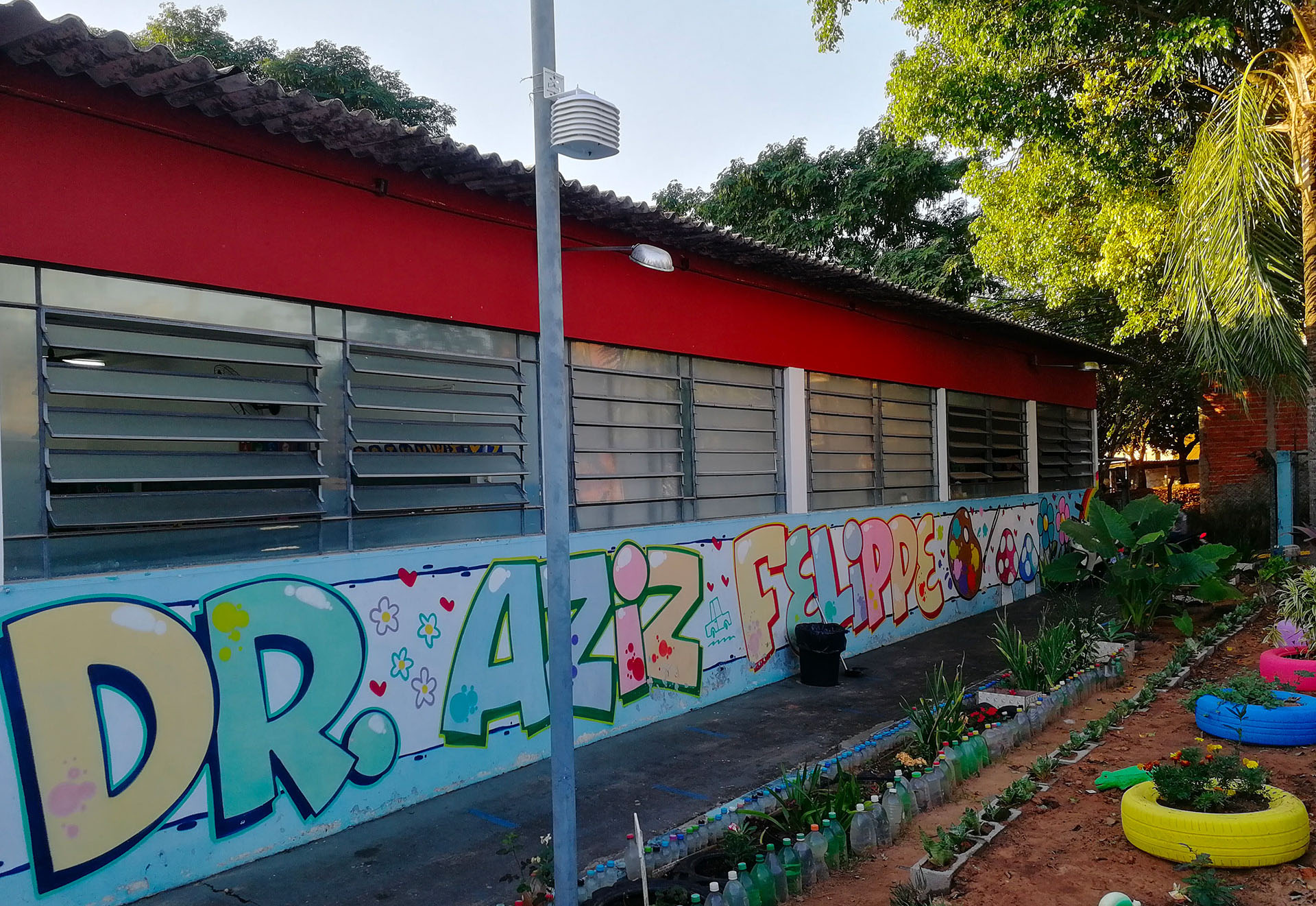
Presidente Prudente, in south-east Brazil, lies around 550 km west of São Paulo. Thanks to a partnership with the Universidade Paulista in São Paulo (UNESP) and the help of the Presidente Prudente municipality's environment and education secretariats, the ALTELYS team was able to install 41 connected stations: in 6 individual houses, 34 schools and 1 company, in this case the local television station. "As a result, a team of journalists followed us to do a report on the installation, which caused a buzz on the university website and on local TV!" explains Vincent Dubreuil, from the LETG Joint Research Unit in Rennes. "And thanks to the partnership with the primary schools, our colleagues on site will be able to give educational talks to the children," he adds. |
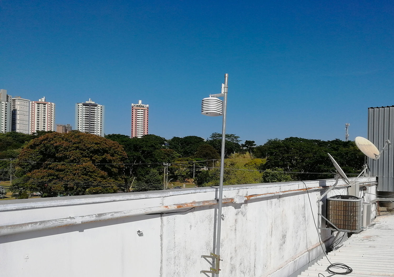
▲ Installed 3 m above the ground, the sensors transmit temperature and humidity data in real time, both inside and outside the building, via WiFi. © ALKANTE |
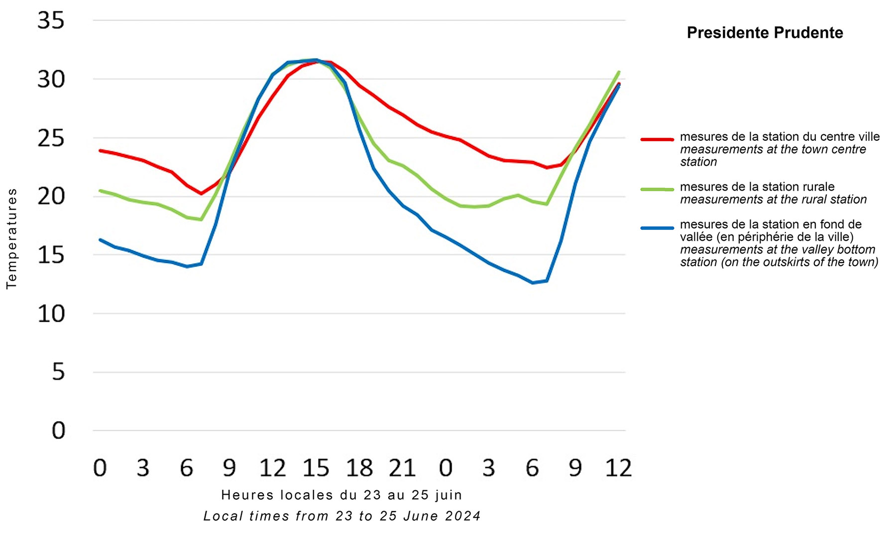 |
◀︎ First UHI measurements at Presidente Prudente: During the day, the temperature is the same everywhere (32°C). At night, the temperature drops more quickly in the countryside, where it is 19°C compared with 23°C in the city, giving a UHI of 4°C. In the valley bottoms, the topographical effect causes temperatures to fall even further, to below 13°C (because the colder, denser air flows by gravity down the slopes and accumulates in the hollows). So there is a 10 degree difference in temperature at night just a few kilometers away... © LETG |
|
💡 Bonus: the TV Fronteira report broadcast (in Brazilian) on 29 June 2024, with Vincent Dubreuil installing the sensors at Presidente Prudente, in the presence of local partners from the University of São Paulo. © TV Fronteira |
|
Gathering user requirements
Since spring 2024, the ALTELYS team has held three user meetings:
- Identify the needs of a thermal platform in the city with the various stakeholders in Rennes (city managers, scientists, citizens).
- Presentation of the broad outlines of the platform identified for verification.
- Presentation of a graphic model of the platform and its main functions.
On site to install the sensors, Vincent Dubreuil was able to involve the Brazilian players from the second meeting, after checking that their needs matched those of the French users.
Development of the online tool
On the basis of these discussions, the team is working on developing the tool itself, testing several types of satellite data, in particular ECOSTRESS, ASTER and LandSat. The latter (LandSat) seems to be the most suitable, as confirmed by a number of exchanges with Vincent Lonjou, a remote sensing specialist at the CNES Lab'OT and leader of the Thermocity project, which is dedicated to thermal data in cities. The team is also looking into the various existing satellite products, available online and free of charge, which meet the required scientific quality criteria and can be integrated into a real-time protocol for cross-referencing with in situ data.
At the same time, the project team is working on the creation of a website that will host, among other things, the visualization platform. To satisfy the various needs expressed by users in terms of information representation, a global cartography is already planned, adapted to a wide audience so that everyone can easily see if they are concerned by a UHI alert. An expert mode will provide access to specific metrics for users such as land managers.
The first prototype will be online in September 2024 and will be reserved exclusively for users to finalize according to their expectations. We won't be revealing anything more at this stage of development!
Research and the private sector: an effective partnership
At the helm of ALTELYS, the LETG laboratory and the Alkante company know each other well: together, they led - and proved their worth - with the Chove-Chuva project and its platform as comprehensive as it is intuitive. And it was their excellent cooperation that prompted them to propose ALTELYS together. "With data interoperability and scalability always in our sights, we're making the most of the experience we gained with Chove-Chuva," says Arnaud Bellec, team leader at Alkante. "In addition to the space R&D aspect, with thermal technology as a key focus, for ALTELYS we are fully integrating XDesign skills to merge user expectations into an attractive and adaptable website that will live on over time". The team is continuing to develop its Chove-Chuva demonstrator.
See you in a few months with an online demonstrator with free access!