

SCOFrance
83Connected participants
Next quarterlyJune 2024
Theme: Water and coastal quality
Coping with natural disasters
The main international institutions are unanimous: the intensity and frequency of natural disasters all over the world will continue to increase as a result of climate change. While we may not be able to counter these extreme events, satellites can help us to understand and anticipate the impacts of some of them.
On Thursday 14 March 2024, the 12th Quarterly Meeting of SCO France welcomed three projects using satellite data to prevent the risk of forest fires, improve resilience to cyclones and automatically detect landslides.
If you have any questions about this quarterly, write to us here.
By Raquel Rodriguez Suquet (CNES) and Julia Pineda (DDTM11)
|
Under the impact of climate change, the worsening of the natural context and the rapid evolution of the stakes exposed, the risk of forest fires is progressing rapidly in the Aude. ALEOFEU should help to identify ways of improving existing tools and models, such as a hazard that can be updated annually and a better assessment of the water status of vegetation. |
|
To remember
- The project makes use of extensive satellite data over a 20-year time span to develop indicators of sensitivity to the risk of forest fires.
- The project produced a dynamic map of the forest fire hazard based on 5 levels of vegetation sensitivity to fire according to the most likely wind scenarios.
- By cross-referencing this mapping with that of the classes of urbanized areas, the tool can be used to target the sectors most at risk and where priority should be given to preventive action.
- Currently under development, the viewing portal will allow distribution at 3 levels:
- Information for local decision-makers ;
- Online mapping for town planning departments;
- Raising awareness among the general public to improve the risk culture of the people of Aude, who are currently more focused on the risk of flooding than the risk of fire, even though this risk is increasing.
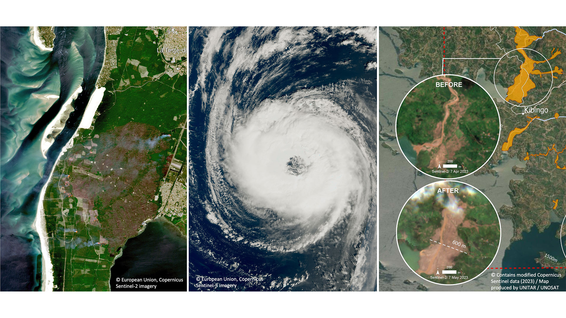
By Christophe Révillion and Florent Veillon (UMR Espace Dev la Réunion)
|
The consequences of climate change can already be measured in terms of tropical cyclones, whose power and area of influence increase as ocean temperatures rise. The Cimopolée project aims to set up an operational online tool that summarizes indicators of the scale of major natural disasters (cyclones, floods, fires) in Madagascar and neighboring countries, using data from the Sentinel-1 and 2 satellites. |
|
To remember
- Reproducible, the tool can be used to visualize the presence of a cyclone in the Indian Ocean in real time.
- Based on the detection of changes (before/after) from Sentinel-1 and 2 data, it also offers the possibility of visualizing flooded areas with all the contextual information.
- Requiring no knowledge of satellite image acquisition and processing, the tool is being co-constructed with the Madagascan partners so that it can be integrated into their national risk management process as quickly as possible.
- The start of the project is presented in the news Facing cyclones with Cimopolée (23/11/2023)
By Jean-Philippe Malet (University of Strasbourg) and Benoit SMETS (Royal Museum for Central Africa)
|
GeoHaTACC aims to detect and inventory hydrogeological hazards in tropical environments and to document the consequences of climate change on these hazards. An operational toolbox combining a variety of sources of information, the demonstrator is being implemented in Rwanda, an African country particularly affected by these events, with a view to its eventual transfer to other regions. |
|
To remember
- Hydrogeological hazards often consist of landslides following torrential rains.
- The project combines a satellite-based approach, to detecting ground movements, with automated analysis of articles in various media (web scraping) to supplement and validate the remote sensing information. It then becomes possible to create catalogues of events and link them with potential trigger thresholds, particularly meteorological ones, to produce hazard estimates and forecasts.
- With excellent results already, space imagery is proving that it can play a major role in countries such as Rwanda, where there is little or no documentation of these phenomena, as well as for the international hydro-geological hazard community.
- + More details in the article GeoHaTACC or satellite optical data to detect geo-hydrological hazards(11/01/2024)
🔎 To find out more: natural disasters can lead to other disasters of an industrial nature in their wake. Find out how this alchemy of risks is dealt with in France in our One-to-one with INERIS.