

SCOFrance
85Geographical tiles
Useful linksTheia article
Presentation of the Sat4BNDB project
Key wordsAlbedo, urban heat island, building renovation plan, CSTB, ADEME
Cities: Sat4BDNB operationalizes albedo production on a national scale
In September 2023, we reported on the remarkable Thermocity project, a pioneering use of spatial data to study UHI, which has inspired other projects and partners. Given the effectiveness of the results, the CSTB (French Scientific and technical center for building , Centre Scientifique et Technique du Bâtiment) wanted to transpose this approach to a national scale by updating its National Building Database (BDNB) with indicators of urban overheating and the associated vulnerability of the population. This has given rise to the Sat4BDNB project, which was accredited SCO label in March 2022, in close partnership with the French space agency CNES, which is providing the space data needed to model the urban heat island.
National albedo available on Theia
|
In the current context of climate change, the main problem facing cities is the phenomenon of urban heat islands (UHIs), i.e. neighborhoods which, due to their morphology and materials, turn into summer hotbeds day and night. Since more than 50% of UHI magnitude is determined by albedo and land use, Sat4BDNB set out to produce systematic albedo mapping at 10-meter resolution using Sentinel-2 data. Logically, the Theia cluster is responsible for disseminating this measurement. |
AlbedoAlbedo is the reflective power of a surface, i.e. the proportion of solar radiation that is reflected back into the atmosphere. Considered an essential climate variable, albedo is the 3rd lever for mitigating global warming (after reducing greenhouse gases and storing carbon in the soil) by "playing" on the reflective power of surfaces to reduce heat storage. |
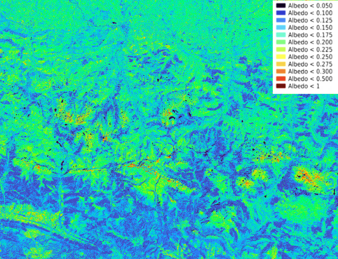
Sentinel-2 albedo on tile 31TCH with part of the Pyrenees. © CNES
As Vincent Lonjou, a remote sensing expert at CNES Lab'OT who took part in both projects, points out, "It's in the DNA of SCO projects to draw on the scientific community and existing infrastructures. THEIA already hosts a collection of data from the SCO THERMOCITY project (Here). It was therefore only natural to call on their services once again to distribute albedo data from Sat4BDNB. What's more, by offering open-access data, THEIA meets SCO's community feedback requirements".
Thanks to the satellite products developed, CSTB will be able to define an urban heat island sensitivity indicator. By cross-referencing this with socio-economic indices, it will be able to calculate morbidity indicators and, thanks to its remarkable expertise, define and evaluate the cost of priority building renovation plans. The systematic measurement of albedo will also enable him to measure the effects of the actions undertaken, which are essentially based on revegetation and whitening.
👉View and download data on Theia (type #S2Albedo in the search bar)
Apply measures to current adaptation cases
Work will now continue alongside ADEME, which will use multi-year albedo production to assess the evolution of UHIs in France as part of the state start-up "Cooler my city" (Plus fraiche ma ville).
Vincent Lonjou takes this opportunity to emphasize that "the SCO is playing its priming role to perfection, and the continuation of the Sat4BDNB project within an ADEME framework would be an exceptional opportunity. It would bring together two major institutional players in the transition of cities: ADEME, the French agency for ecological transition, and CSTB, the French Scientific and Technical Centre for Building".